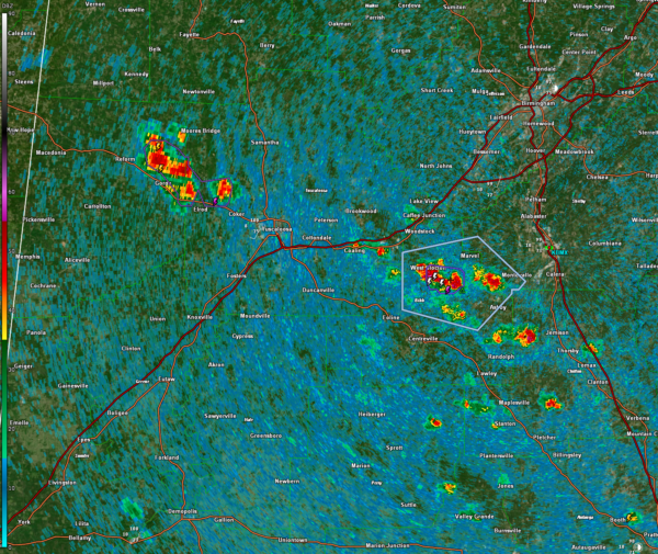
Active Storms This Afternoon
Be alert for the threat of damaging winds from any stronger storms that develop in the hot, humid, an dunstable conditions across North and Central Alabama this afternoon.
Right now, they are active from northern Pickens into western Tuscaloosa Counties, and especially in Bibb, southwestern Shelby, and Chilton Counties.
A significant weather advisory was just posted for parts of Bibb and Shelby. This is one level below a severe thunderstorm warning, which there will undoubtedly be some of this afternoon.
Other isolated storms are popping up across Perry, Marengo, and Autauga Counties.
Be alert for winds that could gust to 40 mph from these storms. Any storms that do become severe could produce wind gusts to 60 mph as well as small hail. All of them will have torrential rain and deadly lightning.
Also beginning to see clearer indications that we will have a tropical depression in the Gulf by late in the weekend into early next week. With the warm water and favorable conditions, it could become a tropical storm or perhaps stronger. It will affect the Florida Peninsula, and not the Panhandle. but could bring rip current issues to the beaches of Alabama and Northwest Florida.
LATE BREAKING NEWS
The morning runs of the global models are trending a little more westward with the storm. The GFS takes it into the eastern Panhandle between Destin and Panama City. The Euro is more eastern, bringing the center into the Big Bend area of Florida from Apalachicola to Cedar Key, north of Tampa. The Eurp brings it in as a 55-65 mph tropical storm. The GFS has it as a 80-90 mph hurricane.
The Gulf waters are about as warm as it gets. This is a foreboding sign that it could be stronger than we think. There are some concerns about wind shear, but the models indicate lessening shear. And we know that Gulf storms can often be stronger than initial indications show.
Category: Alabama's Weather, ALL POSTS, Severe Weather


