Midday Nowcast: Blistering Late Summer Heat
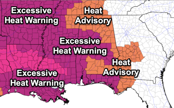
New day, same forecast as the strong upper high remains in place across the Mississippi Valley. Our weather remains mostly dry and very hot with highs this week across Alabama ranging from 95°-105°. Heat index value values will be in the 105°-115° range, and an excessive heat warning and heat advisories are in effect today and tomorrow, and these will likely continue into the weekend. Rain chances are near zero most of the week due to the sinking air under the upper high. An isolated shower or storm could pop up somewhere across Alabama on a day or two, but most of the state will stay dry until the weekend.
WEEKEND WEATHER: The weather won’t change much Saturday with very hot and mainly dry conditions, but heat levels begin to drop Sunday as the upper ridge weakens and shifts to the west. Sunday’s high will be in the low to mid 90s, and a few afternoon showers or storms could pop up thanks to the cooler air aloft.
FOOTBALL WEATHER: For the first week of high school football, it will be a very warm, humid night across Alabama Friday night. The sky will be clear with temperatures falling through the 80s during the game.
Saturday, Jacksonville State hosts the University of Texas at El Paso (4:30p CT kickoff) at Burgess-Snow Field; the sky will be mostly clear and the day will be very hot. Expect a kickoff temperature near 97°, falling into the upper 80s by the final whistle.
NEXT WEEK: Rolling into the final week of August, highs look to drop into the upper 80s to low 90s through the first half of the week, and we will mention a chance of scattered showers and storms daily, more typical of later August in Alabama.
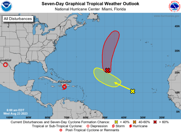
IN THE TROPICS: Harold will dissipate over Northern Mexico the next couple of days. Franklin is moving toward the north near 10 mph, and a north-northeastward motion is expected for the next day or so, followed by a turn toward the northeast and east-northeast on Thursday. On the forecast track, the center of Franklin is expected to cross the island of Hispaniola today and emerge over the southwestern Atlantic waters later today or tonight.
Maximum sustained winds are near 50 mph. Some weakening is likely today while Franklin moves over Hispaniola, followed by re-strengthening beginning on Thursday after the center moves over the Atlantic. As the system strengthens, it is expected to become our second hurricane of the season this weekend.
Two other features in the eastern Atlantic could develop over the next several days, but are no threat to the U.S.
Next several names: Idalia, Jose, and Katia.
BEACH FORECAST CENTER: Get the latest weather and rip current forecasts for the beaches from Fort Morgan to Panama City on our Beach Forecast Center page. There, you can select the forecast of the region that you are interested in visiting.
WORLD TEMPERATURE EXTREMES: Over the last 24 hours, the highest observation outside the U.S. was 121.8F at Heat, Iraq. The lowest observation was -105.7F Dome C, Antarctica.
CONTIGUOUS TEMPERATURE EXTREMES: Over the last 24 hours, the highest observation was 108F at Hebron, NE; Winner, SD; Concordia and Abilene, KS. The lowest observation was 32F at Peter Sinks, UT.
Category: Alabama's Weather, ALL POSTS


