We Have Emily in the Atlantic…and It’s Not From TD6…An Update on the Tropics (Including Hilary!)
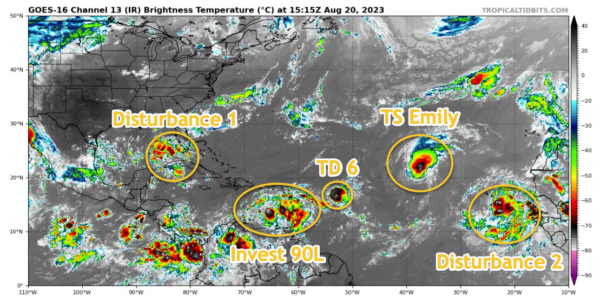
Emily has formed from what was Invest AL90 according to satellite data. The system is some 1600 miles west of the Cabo Verde Islands. It is expected to be short lived, and turn to the north far out over the open Atlantic as a large weakness develops over the Atlantic and a trough forms over eastern North America. It should weaken to a depression by Tuesday and a post-tropical remnant low shortly thereafter.
TD #6 is about 450 miles east of the northern Leewards. It is moving west but will weaken into a remnant low by tomorrow. It is no threat.
Invest 90L is over the southeastern Caribbean this morning with its associated area of disturbed weather. It is expected to become a tropical depression in the next 48 hours as it moves west northwest over the Caribbean. By Tuesday, it should turn north over Hispaniola and move into the Atlantic. Hurricane Hunters are scheduled to investigate this disturbance later today. It will be interesting to see if edges close to New England or the Maritimes of Canada by Monday the 28th.
The disturbance labelled Disturbance #1 on my map is a disturbed area of weather over the southeast Gulf. It is expected to slowly develop as it moves westward across the Gulf of Mexico, steered by a large area of high pressure to the north. It will run out of water and time as it steams toward Texas. It could become a depression or a tropical storm before it reaches the Texas Coast late tomorrow night or early Tuesday.
Finally, the furthest out disturbance is labelled #2, in the far eastern Atlantic. It will recurve also, but it could become the strongest storm or hurricane of the bunch. It will look like planes on approach to O’Hare by ten days from now with two hurricanes slipping out ahead of the trough.
The next name on the list for the Atlantic is Franklin, followed by Gert.
Now the latest on now Tropical Storm Hilary in the eastern Pacific:
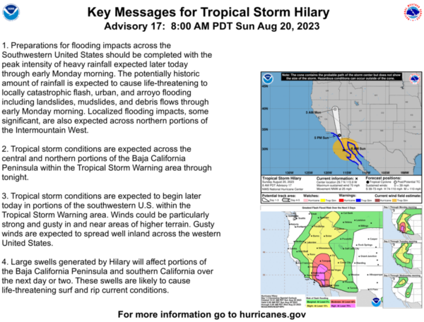
…The center of Hilary is located near Punta Eugenia on the west coast of Baja.
…It is moving faster, to the north northwest at 25 mph.
…Top winds are 70 mph and the central pressure is 984 mb.
…By late this afternoon, the center will be near or just east of San Diego.
…Very heavy rains across Southern California will cause significant flash flooding, particularly in the mountains and desert areas east and northeast of San Diego and Los Angeles.
…Winds will reach 30-35 mph in the San Diego area and 40-60 mph in the Desert Areas of California into the Colorado River area of Arizona. Winds will increase in Los Angeles later this afternoon reaching 25-30 mph this evening.
…There may be tornadoes this afternoon and evening in the interior areas of Southern California into the Las Vegas area of Nevada.
High wind watches and warnings continue all the way into Idaho and eastern Oregon.
Category: Alabama's Weather, ALL POSTS, Tropical


