Midday Nowcast: Sunny in Alabama; Watching the Tropics
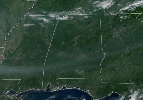
It is another sun-filled day of weather across North/Central Alabama and highs this afternoon are in the low 90s. There are some fair weather cumulus clouds as well as some haze from Canadian wildfire smoke, but other than that, it is a calm day of weather for Alabama. The weather will be dry for most of the state through the weekend with rising heat levels; highs will be in the low to mid 90s with mostly sunny days and fair nights. A few isolated storms could show up Saturday and Sunday over southern quarter of Alabama, but even there most places will stay dry.
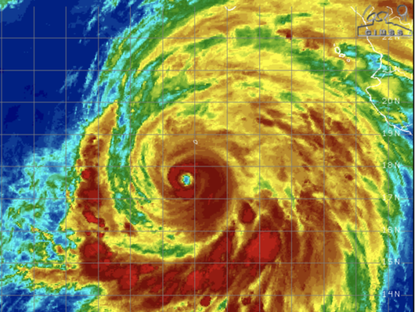
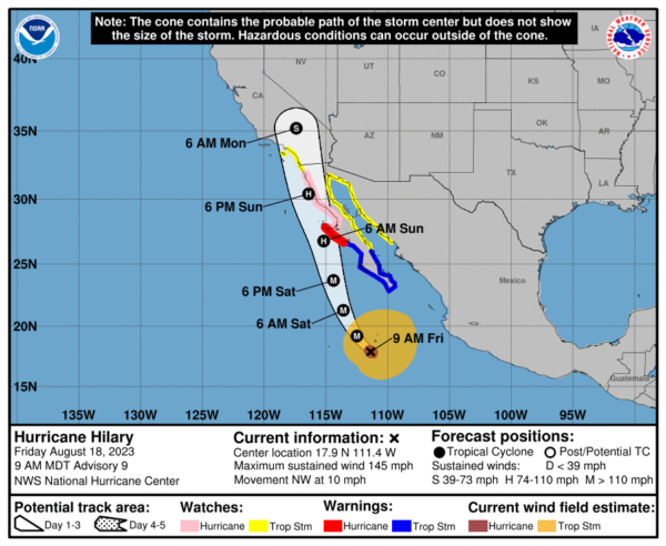
HURRICANE HILARY: Over in the Eastern Pacific, Hilary is a category 4 hurricane. Hilary is moving toward the northwest near 10 mph. A turn toward the north-northwest is expected today and tonight, followed by a faster motion toward the north Saturday night and Sunday. On the forecast track, the center of Hilary will move close to the west coast of the Baja California peninsula over the weekend and reach southern California by Sunday night.
Maximum sustained winds remain near 145 mph with higher gusts. Hilary is a category 4 hurricane on the Saffir-Simpson Hurricane Wind Scale. Fluctuations in intensity are likely over the next day or so. Weakening is expected to begin by Saturday, but Hilary will still be a hurricane when it approaches the west coast of the Baja California peninsula Saturday night and Sunday. Hilary is expected to weaken to a tropical storm by Sunday afternoon before it reaches southern California.
Hurricane-force winds extend outward up to 45 miles from the center and tropical-storm-force winds extend outward up to 290 miles. The estimated minimum central pressure is 939 mb (27.73 inches).
INTO NEXT WEEK: Rolling into next week, the upper level ridge intensifies over the Deep South, bringing hot and mostly dry weather to the Alabama. Any showers and storms will remain fairly isolated, rain chances will remain less than 20% daily. Highs will be in the mid to upper 90s, with some low 100s likely in those hotter spots.
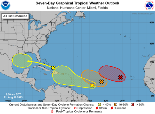
IN THE TROPICS: In the Eastern Tropical Atlantic (AL98): Showers and thunderstorms continue to show some signs of organization in association with a broad area of low pressure located a few hundred miles west of the Cabo Verde Islands. Environmental conditions appear generally favorable for additional development of this system, and a tropical depression is likely to form over the weekend while it moves toward the west-northwest or northwest at about 10 mph across the eastern tropical Atlantic. By early next week, upper-level winds over the system are forecast to increase, and further development is not expected. Formation chance through 48 hours…medium…60 percent. Formation chance through 7 days…high…70 percent.
In the Central Tropical Atlantic (AL99): An elongated trough of low pressure located roughly halfway between the Cabo Verde Islands and the Lesser Antilles is producing some disorganized showers and thunderstorms. Environmental conditions are only marginally conducive for further development of this system, but a tropical depression could still form during the next couple of days while it moves west-northwestward at 10 to 15 mph across the central tropical Atlantic. Thereafter, upper-level winds are forecast to become unfavorable for any further development. Formation chance through 48 hours…medium…40 percent. Formation chance through 7 days…medium…40 percent.
East-Southeast of the Lesser Antilles, another area of low pressure could form in a day or so from an elongated trough of low pressure located several hundred miles to the east-southeast of the Lesser Antilles. Some slow development of this system is possible over the weekend and into early next week as it moves generally west-northwestward at 10 to 15 mph across the Lesser Antilles and into the northeastern Caribbean Sea. Formation chance through 48 hours…low…10 percent. Formation chance through 7 days…low…30 percent.
Finally, in the Western Gulf of Mexico, An area of disturbed weather located just north of Hispaniola is forecast to move into the Gulf of Mexico by early next week, where a broad area of low pressure could form. Some slow development of this system is possible thereafter as it moves westward and approaches the western Gulf of Mexico coastline by the middle of next week. Formation chance through 48 hours…low…near 0 percent. Formation chance through 7 days…low…30 percent.
The next few names up are Emily, Franklin, Gert, and Harold.
BEACH FORECAST CENTER: Get the latest weather and rip current forecasts for the beaches from Fort Morgan to Panama City on our Beach Forecast Center page. There, you can select the forecast of the region that you are interested in visiting.
CONTIGUOUS TEMPERATURE EXTREMES: Over the last 24 hours, the highest observation was 118F at Death Valley, CA. The lowest observation was 35F at Hovland, MN.
Category: Alabama's Weather, ALL POSTS


