Midday Nowcast: A Nice, Sunny August Day
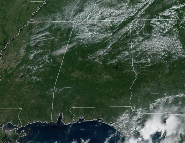
It is another pleasant August day across Alabama as low humidity remains in places. Highs this afternoon are ranging from the upper 80s to lower 90s under a sky full of sunshine. Tonight will be comfortable, but lows will only fall into the 60s overnight.
TOMORROW AND THE WEEKEND: The weather will be dry for most of the state through the weekend with rising heat levels; highs will be in the low to mid 90s with mostly sunny days and fair nights. A few isolated storms could show up Saturday and Sunday over southern quarter of Alabama, but even there most places will stay dry.
INTO NEXT WEEK: Rolling into next week, the upper level ridge intensifies over the Deep South, bringing hot and mostly dry weather to the Alabama. Any showers and storms will remain fairly isolated, rain chances will remain less than 20% daily. Highs will be in the mid to upper 90s. We still have a lot of summer left, and we may not have seen our hottest weather yet…
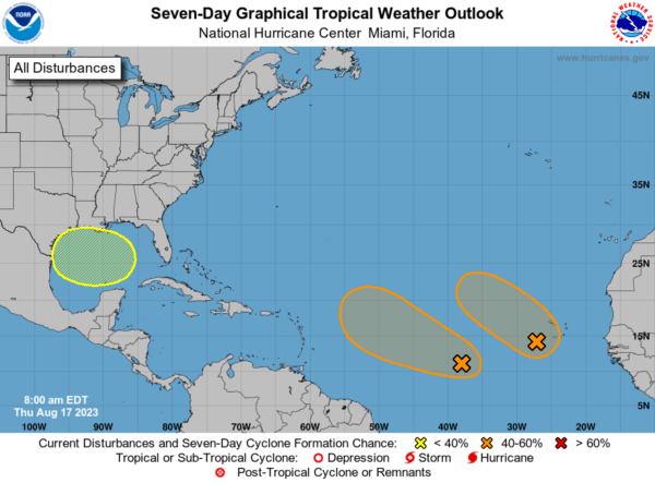
IN THE TROPICS: In the Central Atlantic Invest 99L: Disorganized showers and thunderstorms continue in association with an elongated trough of low pressure centered over 900 miles west-southwest of the Cabo Verde Islands. Environmental conditions appear conducive for gradual development of this system, and a tropical depression could form during the next several days while it moves west-northwestward at 10 to 15 mph across the central tropical Atlantic. Formation chance through 48 hours…medium…40 percent. Formation chance through 7 days…medium…60 percent.
In the Eastern Atlantic Invest 98L: A broad area of low pressure, partially associated with a tropical wave, is producing a large area of disorganized showers and thunderstorms near and to the southwest of the Cabo Verde Islands. Further development of this low is possible while it moves toward the west-northwest or northwest at around 10 mph across the eastern tropical Atlantic, and a tropical depression could form over the weekend before environmental conditions become unfavorable for development early next week. Formation chance through 48 hours…medium…40 percent. Formation chance through 7 days…medium…60 percent.
In the Western Gulf of Mexico, a broad area of low pressure could form in the central or western Gulf of Mexico by the beginning of next week. Some slow development of this system is possible thereafter as it moves westward and approaches the western Gulf of Mexico coastline by the middle of next week. Formation chance through 7 days…low…30 percent.
The next few names up are Emily, Franklin, and Gert.
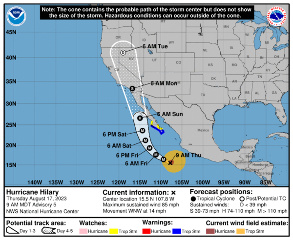
Over in the Eastern Pacific, Hilary is now a Hurricane. Hilary is moving toward the west-northwest near 14 mph, and this general motion is expected to continue through tonight. A turn toward the northwest is expected Friday morning, followed by a turn toward the north-northwest and north on Saturday. On the forecast track, the center of Hilary will approach the Baja California peninsula over the weekend.
Maximum sustained winds have increased to near 85 mph with higher gusts. Rapid strengthening is forecast during the next day or so, and Hilary could become a major hurricane later today. Hurricane-force winds extend outward up to 70 miles from the center and tropical-storm-force winds extend outward up to 275 miles. The estimated minimum central pressure is 980 mb (28.94 inches).
BEACH FORECAST CENTER: Get the latest weather and rip current forecasts for the beaches from Fort Morgan to Panama City on our Beach Forecast Center page. There, you can select the forecast of the region that you are interested in visiting.
WORLD TEMPERATURE EXTREMES: Over the last 24 hours, the highest observation outside the U.S. was 121.6F at Semawa, Iraq. The lowest observation was -93.8F Vostok, Antarctica.
CONTIGUOUS TEMPERATURE EXTREMES: Over the last 24 hours, the highest observation was 117F at Death Valley, CA. The lowest observation was 35F at Big Piney, WY.
Category: Alabama's Weather, ALL POSTS


