Looking Like Another Severe Thunderstorm Watch for North Alabama
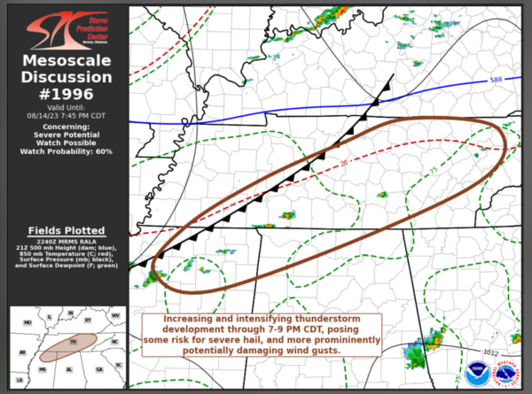
The SPC just issued a mesoscale discussion hinting that we may very well have to go under another severe thunderstorm watch this evening in North Alabama.
Storms are initiating now from the Mississippi Delta near Clarksdale to north of Tupelo to near the Northwest Corner of Alabama to near Tullahoma Tennessee, ahead of a cold front that will enter the state later tonight.
The line of strong storms may not be able to make it very far south through midnight, so there could be a few thunderstorms in the same locations. It will weaken before moving south tomorrow morning, possibly re-generating over southeastern sections of the area in the afternoon. Damaging winds and quarter sized hail are possible between 106 pm tomorrow near and south of I-85.
As you would guess, instability values are high, between 4-5,000 joules, with speed shear increasing ahead of the front. Plenty of dry air aloft means high downdraft CAPES, so a high propensity for producing damaging wind gusts.
Low level lapse rates are very steep, but the mid-level rates are not quite as good.
No low level shear though, so no tornadoes.
Here is the text of the MCD:
Mesoscale Discussion 1996
NWS Storm Prediction Center Norman OK
0543 PM CDT Mon Aug 14 2023
Areas affected…eastern and middle Tennessee into northwestern
Alabama and northern Mississippi
Concerning…Severe potential…Watch possible
Valid 142243Z – 150045Z
Probability of Watch Issuance…60 percent
SUMMARY…Scattered thunderstorm activity is expected to gradually
initiate and intensify through 7-9 PM CDT, posing some risk for
severe hail, then increasing potential for damaging wind gusts.
Trends are being monitored for the possibility of a severe weather
watch.
DISCUSSION…Thunderstorms have initiated in the presence of
moderate to large mixed-layer CAPE across northern Mississippi.
This appears just south of stronger westerly deep-layer mean flow
and shear near the southern fringe of a mid-level jet nosing across
the Ohio Valley through Mid Atlantic. However, deepening convective
development is underway east-northeastward through middle and
eastern Tennessee, in a similarly unstable environment, downstream
of a slowly southward advancing cold front.
Particularly north of the southern Tennessee border vicinity, 30-40
kt westerly deep-layer mean flow and shear appears conducive to
organizing convection, including supercell structures, as
thunderstorms continue to develop through the 7-9 PM CDT time frame.
While modest to small low-level hodographs may tend to limit the
potential for tornadoes, stronger cells may initially pose some risk
for severe hail, before potentially damaging wind gusts become the
more prominent hazard as activity propagates eastward.
South of the southern Tennessee border, mean wind fields are weaker,
but steeper lapse rates associated with a more strongly heated and
deeply mixed boundary-layer may compensate and support the risk for
potentially damaging wind gusts.
..Kerr/Guyer.. 08/14/2023
Category: Alabama's Weather, ALL POSTS, Severe Weather


