
Sunday Weather Briefing — A Late Summer Scorcher with Scattered Storms
While Sunday Will Be Quieter, The Sweltering Heat Hangs Around
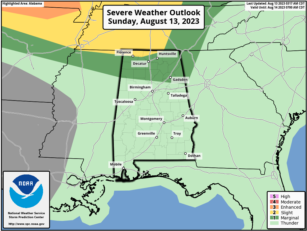
Sunday will feature very hot conditions once again along with high humidity levels, and the heat products have already been issued across the area (listed below). We’ll have a chance of a few isolated to scattered showers and storms across the area, some of which may be strong to severe. A Marginal Risk is up for nearly all of North Alabama and stretches as far south as Winfield to Hayden to Jacksonville, as damaging winds will be possible. A Slight Risk is up for the extreme northern parts of North Alabama. Highs in the mid 90s to the lower 100s.
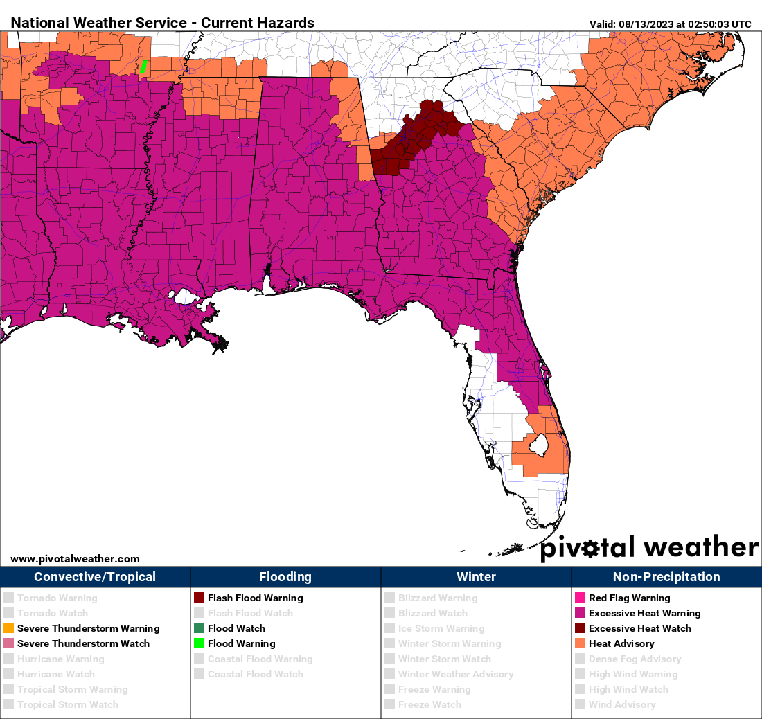
Excessive Heat Warning | (Expires at 8 pm): Colbert, Cullman, Franklin, Lauderdale, Lawrence, Limestone, Madison, Marshall, and Morgan counties in North Alabama. (Expires at 9 pm): Autauga, Barbour, Bibb, Bullock, Chilton, Coosa, Dallas, Elmore, Fayette, Greene, Hale, Jefferson, Lamar, Lee, Lowndes, Macon, Marengo, Montgomery, Perry, Pickens, Pike, Russell, Shelby, Sumter, Tallapoosa, Tuscaloosa, Walker Blount, Clay, Marion, St. Clair, Talladega, and Winston counties.
Heat Advisory | (Expires at 8 pm): DeKalb and Jackson counties in North Alabama. (Expires at 9 pm): Calhoun, Chambers, Cherokee, Cleburne, Etowah, and Randolph counties in Central Alabama.
Hot to Start the Week; Heat & Rain Relief is On Its Way
An upper ridge over the Gulf Coast states will keep thunderstorm activity lower and will extend the heat misery through Monday. It will be hot, humid, with a chance of a few isolated to scattered afternoon showers and storms. Highs in the mid 90s to the lower 100s.
A front will push into the area during the predawn hours on Tuesday, but the better dynamics will remain well off to the north from us; however, a few strong storms may occur over the southern half of the area. We’ll have scattered showers and storms. Highs in the lower 80s to the upper 90s from north to south.
On Wednesday, it will feel much more comfortable outdoors as dewpoints will drop back into the 60s. We’ll actually be dry throughout the day across Central Alabama and highs in the lower 80s to the lower 90s.
The heat levels will slowly start increasing on Thursday, but at this point, dewpoints look to stay lower. It will be another dry day across the area with highs in the mid 80s to the mid 90s.
The airmass across the southeast will become more humid and that will introduce the chance of a few isolated to scattered afternoon showers and storms. Highs in the upper 80s to the mid 90s.
And at the end of the forecast period on Saturday… We’ll continue with hot and humid conditions with a chance of a few isolated to scattered afternoon showers and storms. Highs in the upper 80s to the upper 90s.
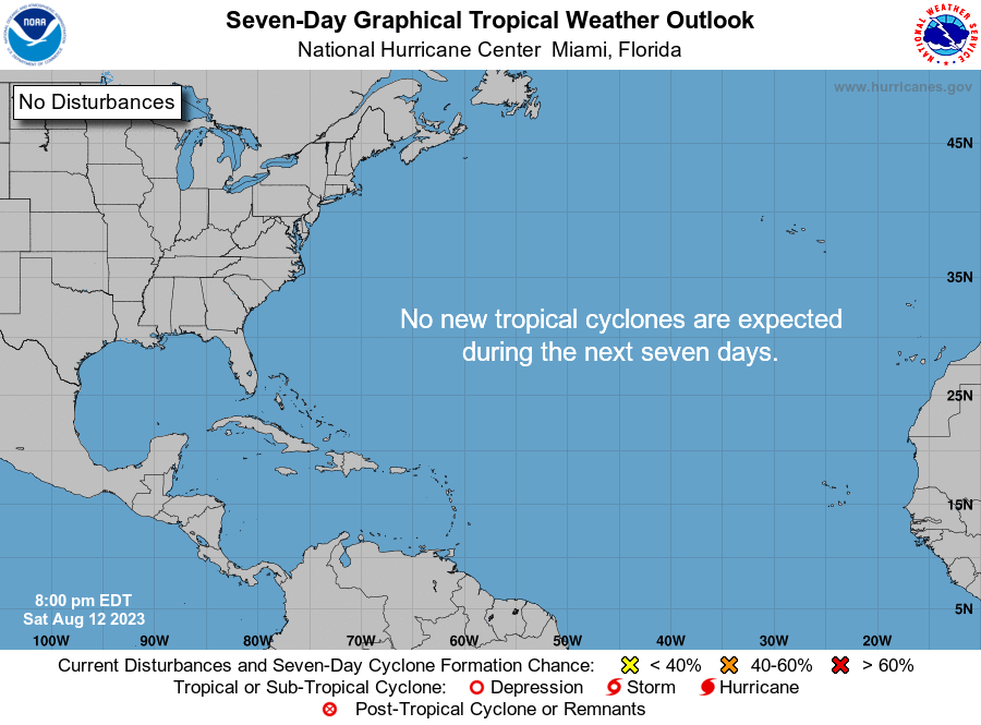
The Tropics
The tropics remain very quiet surprisingly as we are in the peak of the hurricane season. No new tropical cyclones are expected to form throughout the next seven days.
On This Day In Weather History
2004… Hurricane Charley rapidly deepened just hours before landfall near Punta Gorda, Florida, going from a category 2 to a category 4 hurricane. Sustained winds at landfall were 150 mph and the pressure dropped to 941 millibars. Extreme wind damage occurred over all of Charlotte County with an 8-foot storm surge in Lee County. Well over hurricane force winds in gusts occurred far inland as the hurricane accelerated to the northeast. Orlando, Florida measured a peak gust of 105 mph — an all-time record wind gust for this location. 15 people lost their lives to the hurricane and total damage was 14 billion dollars, making Charley the second-costliest hurricane up to this time.
Beach Forecast Center
Get the latest weather and rip current forecasts for the beaches from Dauphin Island, AL, to Panama City Beach, FL, on our Beach Forecast Center page. There, you can select the forecast of the region that you are interested in.
E-Forecast
Get the Alabama Wx Weather Blog’s Seven-Day Forecast delivered directly to your inbox by email twice daily. It is the most detailed weather forecast available in Central Alabama. Subscribe here… It’s free!
WeatherBrains
If you are crazy about weather, this is THE podcast for you! Listen to the latest released episode each Tuesday, or catch up on any episodes that you have missed. The WeatherBrains crew includes your host, James Spann, plus other notable geeks like Troy Kimmel, Bill Murray, Rick Smith, James Aydelott, Jen Narramore, Dr. Neil Jacobs, and Dr. Kim Klockow-McClain. They bring together a wealth of weather knowledge and experience for another fascinating podcast about weather. Available at WeatherBrains.com, or on Apple Podcasts, Google Podcasts, Spotify, or Stitcher.
Category: Alabama's Weather, ALL POSTS, Severe Weather, Tropical, Weather Xtreme Videos
About the Author (Author Profile)
Scott Martin is an operational meteorologist, professional graphic artist, musician, husband, and father. Not only is Scott a member of the National Weather Association, but he is also the Central Alabama Chapter of the NWA president. Scott is also the co-founder of Racecast Weather, which provides forecasts for many racing series across the USA. He also supplies forecasts for the BassMaster Elite Series events including the BassMaster Classic.Subscribe
If you enjoyed this article, subscribe to receive more just like it.


