Wednesday’s Weather Briefing — One More Day Before the Muggies & Storms Return
Tuesday’s Highs Across Central Alabama
100 – Troy
97 – Montgomery
95 – Tuscaloosa
94 – Anniston
94 – Shelby Co. Airport
91 – Birmingham
The Second Day of August
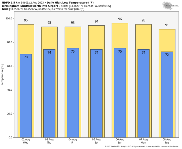
It looks like we may squeeze in one more day of dewpoints remaining below 70º on Wednesday, as the ridge to our west will take just a tad longer to weaken. Nearly everyone will remain dry, but we could see some convective activity move in from the northwest during the late afternoon through the evening; however, rain chances remain very, very small f0r the northwest quarter of the area. You will notice the humidity starting to climb late. Highs in the lower to mid 90s.
Just in case you wanted to know, today is also known as…
• National Ice Cream Sandwich Day
• National Coloring Book Day
Thursday & Friday
The flow will be out of the southwest to south on Thursday which will continue the increase of humidity into Central Alabama. It will be hot and muggy with a good chance of scattered storms during the afternoon to early evening hours. Highs in the upper 80s to the mid 90s.
Friday will be much of the same story with a good chance of scattered storms mainly during the afternoon, but possible throughout the entire day. There will be a little bit of a breeze, gusting up to 20 mph at times. Hot and muggy with highs in the upper 80s to the mid 90s.
The First Weekend of August 2023
Saturday and Sunday look to be more typical for late summer in Central Alabama as it will be hot and humid with scattered afternoon storms possible. We’ll be in the 90s on both days.
A Peek Into the Start of Next Week
Next week, our weather stays active as a trough is progged to move into the northeast, sending more activity down in our direction from the northwest. A front looks to sweep into the area on Monday bringing more scattered to numerous showers and storms. Highs in the lower to mid 90s.
And at the end of our forecast period on Tuesday, the front looks to stall out just to our south and will keep scattered storms possible across the southern half of the area, while locations a bit north of I-20 will stay dry. Highs in the mid 80s to the mid 90s.
The Tropics (7pm Tuesday Evening Update)
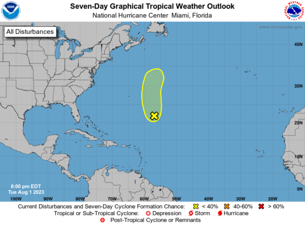
Central Subtropical Atlantic (Invest 96): Showers and thunderstorms remain disorganized in association with a low pressure area located about 600 miles southeast of Bermuda. Environmental conditions are becoming less favorable for tropical cyclone formation, and the low is expected to move northward and merge with a frontal system over the north-central Atlantic in about two to three days.
* Formation chance through 48 hours…low…20 percent.
* Formation chance through 7 days…low…20 percent.
On This Day In Weather History
1989 – Low pressure representing the remains of Hurricane Chantal deluged north central Texas with heavy rain. Up to 6.50 inches drenched Stephens County, and Wichita Falls reported 2.22 inches of rain in just one hour.
Beach Forecast Center
Get the latest weather and rip current forecasts for the beaches from Dauphin Island, AL, to Panama City Beach, FL, on our Beach Forecast Center page. There, you can select the forecast of the region that you are interested in.
E-Forecast
Get the Alabama Wx Weather Blog’s Seven-Day Forecast delivered directly to your inbox by email twice daily. It is the most detailed weather forecast available in Central Alabama. Subscribe here… It’s free!
WeatherBrains
If you are crazy about weather, this is THE podcast for you! Listen to the latest released episode each Tuesday, or catch up on any episodes that you have missed. The WeatherBrains crew includes your host, James Spann, plus other notable geeks like Troy Kimmel, Bill Murray, Rick Smith, James Aydelott, Jen Narramore, Dr. Neil Jacobs, and Dr. Kim Klockow-McClain. They bring together a wealth of weather knowledge and experience for another fascinating podcast about weather. Available at WeatherBrains.com, or on Apple Podcasts, Google Podcasts, Spotify, or Stitcher.
Category: Alabama's Weather, ALL POSTS, Tropical, Weather Xtreme Videos


