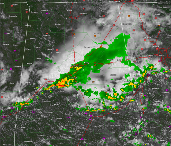
Radar Update at 1:10 p.m.
It’s a stormy Sunday for some across North and Central Alabama as an outflow boundary from overnight storms in Missouri, Arkansas and western Tennessee moved into North Alabama as the heating of the day got going, and it was able to generate a decent line of rain and storms. That line is passing across the I-59 Corridor right now.
Winds gusted to 43 mph at the Birmingham Airport with the outflow alone.
Outflow from these storms has stirred up storm in East Central Alabama. Those storms extend from Autauga County through Elmore, Tallapoosa, and Chambers Counties. Those storms are approaching I-85 at this hour.
There have been a few reports of trees down including western Jefferson County on Birmingport Road and Alliance/Shortcreek Road according to scanner expert John Talbot. A tree was down causing a power outage on Liles Lane in Trussville.
The strongest storms are in Hale, Tuscaloosa and Bibb Counties. Cells from south of Coaling to West Blocton are causing a racket with loud thunder, very heavy rain and gusty winds. Those storms have come the closest to being severe today.
The storm near Dadeville in Tallapoosa County is strong as well. It in ingesting lots of CAPE and should grow stronger as it pushes southeast toward Auburn and Opelika.
A lone cell has formed near Berry in Fayette County.
Skies are clear behind the storm complex so additional storms may form this afternoon, but the coverage doesn’t appear to be very great according to the convection allowing models. We still will make it to 94-95F even in places that have seen rain and storms.
That front will push into Central Alabama overnight and Monday will be dry and hot. Only isolated storms and hot the remainder of the week.
Category: Alabama's Weather, ALL POSTS, Current Warnings, Current Watches, Severe Weather


