Saturday Morning Weather Briefing Video: Heat Advisories Continue Through Tomorrow
Thunderstorms were fairly numerous yesterday afternoon as a strong summer sun worked on a humid airmass across Alabama. A surface low along the Georgia Coast between Jacksonville and Savannah helped to get the storms’ engines going and with all this atmospheric fuel lying around, the storms just had to burn (or rather rain) themselves out. There were a few reports of wind damage from places like Cullman, Hanceville, Bluff Park, Ross Bridge, and Tuscaloosa/Northport. Winds gusted to 38 mph at the Birmingham Airport and 43 mph at the Bessemer Airport. There was even a report of nickel-sized hail from near Madison in North Alabama. The temperature at the Birmingham Airport dropped from 95F to 81F during its afternoon storm, but the mercury recovered to 95F by 4:30, along with a little extra humidity the second go-round.
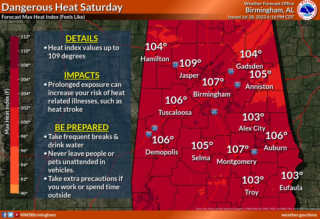
HEAT ADVISORIES CONTINUE for all of North and Central Alabama through Sunday evening, except for the northeastern counties. Heat Index values will reach 107-109F in some locations today and tomorrow. Prolonged exposure can increase your risk of heat related illnesses, such as heat stroke. Be prepared by taking frequent breaks and drinking water. Never leave people or pets unattended in vehicles. Take extra precautions if you work or spend time outside.
SATURDAY RAIN CHANCES: That surface low to our southeast will be meandering around North Florida and weakening, lessening the convergence that it caused on Friday, resulting in fewer of those popcorn showers and storms this afternoon. If you get underneath one, expect very heavy rain, dangerous lightning, and strong, gusty winds. The stronger storms have a small chance of damaging winds to 60 mph or so. We’ve already talked about the heat, so be ready. Highs this afternoon will be in the 94-98F range. Skies will become partly cloudy and it will be calm overnight with lows in the 70s. .
SUNDAY FRONT: By Sunday, the upper trough over eastern Canada will be digging down through the Northeast and Mid-Atlantic states, propelling a weak cool front our way from the north and northeast as we set up under the edge of another northwesterly flow. A few showers and maybe a thunderstorm could flare up Sunday morning over North and Northeast Alabama, and it looks like a passing disturbance could trigger a cluster of storms across Central Alabama Sunday afternoon and evening as the front drops southward. Those storms could be on the strong to severe side with damaging winds possible. Afternoon readings will reach 94-99F if no showers interfere.
DID I SAY FRONT? By Monday morning, our little front that can will be lying across the middle part of Alabama. Its convergence will be trying hard to produce a decent chance of showers and storms, mainly across South Central Alabama. The heat will back off a tad across the Tennessee Valley, with highs in the lower 90s. Meanwhile, the rest of Central Alabama will still be roasting in the 94-98F range.
MIDWEEK: Tuesday and Wednesday look like they could be mainly dry with high pressure in charge. The only fly in the ointment would be any showers and storms that form to our northwest and come this way. Highs will be near 90F to the lower 90s up north, with middle 90s hanging in around Central Alabama.
THURSDAY INTO THE WEEKEND: By Thursday, the ridge across the South should begin to buckle on its eastern flank, and showers and thunderstorms will be on the increase. Rain chances look pretty good, especially by Saturday and Sunday. High temperatures will be in the middle 90s through Saturday, with readings around 90F Sunday and Monday it looks like with those better rain chances.
VOODOO WEEK TWO: It looks like a full latitude trough sets up over the eastern half of the United States by the following week. That means good rain chances until about Thursday, when we will get a temporary respite.
BEACHCAST: Scattered mainly afternoon and evening showers and storms will be the rule along the beautiful beaches of Alabama and Northwest Florida in the week ahead. It won’t rain all day any time but there is a good chance that part of each day could feature a storm. Highs will be in the middle 90s, lows in the upper 70s. Some overnight readings won’t get cooler than 80F. Water temperatures are running in the lower 80s. The rip current risk looks low for the next few days.
Click here to see the Beach Forecast Center page.
IN THE TROPICS: A disturbance 1,200 miles east of the Lesser Antilles has a 70% chance of becoming a tropical cyclone over the next few days as it curves northward well to the northeast of the islands. Elsewhere, nothing important in the tropics for the foreseeable future.
NATIONALLY: Heat advisories and excessive heat warnings are the story across much of the United States once again on this Saturday. It will 115F today in Phoenix today, 106F in Wichita Falls, Texas.
DANCING WITH THE STATS: El Paso hit 105F on Friday, breaking the previous record high of 104F.
ADVERTISE WITH US: Deliver your message to a highly engaged audience by advertising on the AlabamaWX.com website. We have a lot of big plans for this year. Don’t miss out! We can customize a creative, flexible, and affordable package that will suit your organization’s needs. Contact me, Bill Murray, at (205) 687-0782 and let’s talk.
WEATHERBRAINS: This week, the panel is entertaining Tabitha Bartoe, a TV met who was released from her job at a Knoxville station because of her hairstyle. Where do station’s get to draw the line on personal appearance? Check out the show at www.WeatherBrains.com. You can also subscribe on iTunes. You can watch the show live on our new YouTube channel for the show.You will be able to see the show on the James Spann 24×7 weather channel on cable or directly over the air on the dot 2 feed.
ON THIS DATE IN 1978: Tropical Storm Amelia moves inland on the Texas coast 40 miles north of Brownsville and moved northward into Texas. The storm would not be known for damage along the coast, but rather for extensive flooding that it caused in the Texas Hill Country and in the Big Country Area near Abilene. Follow my weather history tweets on Twitter. I am @wxhistorian at Twitter.com.
Category: Alabama's Weather, ALL POSTS, Severe Weather
About the Author (Author Profile)
Bill Murray is the President of The Weather Factory. He is the site's official weather historian and a weekend forecaster. He also anchors the site's severe weather coverage. Bill Murray is the proud holder of National Weather Association Digital Seal #0001 @wxhistorianSubscribe
If you enjoyed this article, subscribe to receive more just like it.


