Midday Nowcast: Very Hot Late July Weather
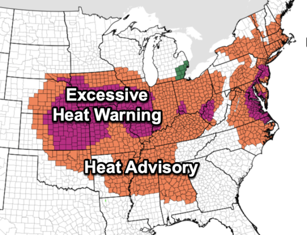
Most of North and Central Alabama is under a Heat Advisory today as heat index values are over 105° this afternoon. The Heat advisory continues for tomorrow as well. We are seeing more sun than clouds with actual air temperatures in the mid to upper 90s today through Sunday. Average high for Birmingham this time of year is 91°.
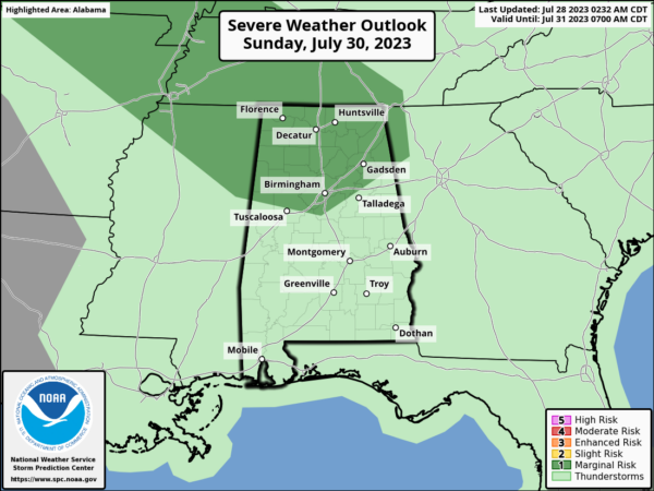
Rain chances are low, but not zero, and for now rain chances are in the 20-30% range. Most locations will remain dry, but if you find yourself under one of those random, afternoon and evening showers and storms, you can expect gusty winds, torrential rainfall, which can lead to areas of isolated flash flooding, and tremendous amounts of lightning. We do note SPC has put North Alabama in a “marginal risk” (level 1/5) of severe thunderstorms Sunday. This is for potential for strong storms over western Tennessee to enter Alabama in a northwest flow aloft Sunday afternoon.
ACROSS THE USA: It is not just Alabama with heat alerts…Dangerously high heat indices will impact millions of people as the heat spreads from the central U.S. into the Mid-Atlantic and Northeast, and persists in the Southwest. A weather system will interact with that atmosphere with potential for severe storms from the Midwest to the Great Lakes. Critical fire weather conditions, including dry thunderstorm potential, are in the northern Great Basin.
NEXT WEEK: The ridge will remain in place and August will start the way July ends…very hot with isolated afternoon storms. Highs will continue to be in the mid to upper 90s much of the week. Towards the and of the week, the ridge could weaken a bit, and that would allow heat levels to decrease some, and rain chances to increase.
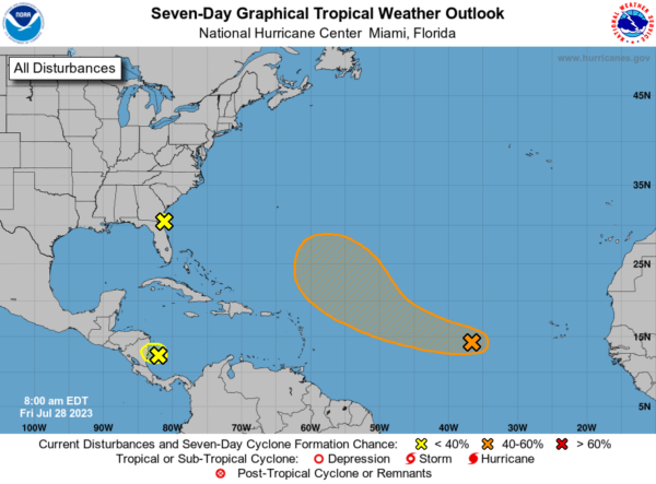
IN THE TROPICS: A couple of areas of interest that are not expected to develop. However, shower and thunderstorm activity associated with a tropical wave located about midway between the Cabo Verde Islands and the Lesser Antilles has increased since yesterday. Environmental conditions are expected to be favorable for additional gradual development of this system during the next few days, and a tropical depression could form early next week while the system moves generally west-northwestward over the tropical Atlantic. Formation chance through 48 hours…low…20 percent. Formation chance through 7 days…medium…60 percent.
BEACH FORECAST CENTER: Get the latest weather and rip current forecasts for the beaches from Fort Morgan to Panama City on our Beach Forecast Center page. There, you can select the forecast of the region that you are interested in visiting.
WORLD TEMPERATURE EXTREMES: Over the last 24 hours, the highest observation outside the U.S. was 121.6F at Kuwait International Airport, Kuwait. The lowest observation was -105.9F Dome C, Antarctica.
CONTIGUOUS TEMPERATURE EXTREMES: Over the last 24 hours, the highest observation was 125F at Death Valley, CA. The lowest observation was 27F at Bynum, MT.
Category: Alabama's Weather, ALL POSTS
About the Author (Author Profile)
Macon, Georgia Television Chief Meteorologist, Birmingham native, and long time Contributor on AlabamaWX. Stormchaser. I did not choose Weather, it chose Me. College Football Fanatic. @Ryan_StinnetSubscribe
If you enjoyed this article, subscribe to receive more just like it.


