Saturday Weather Briefing — Rain & Storms Today; Sunny & Less Humid for Most on Sunday
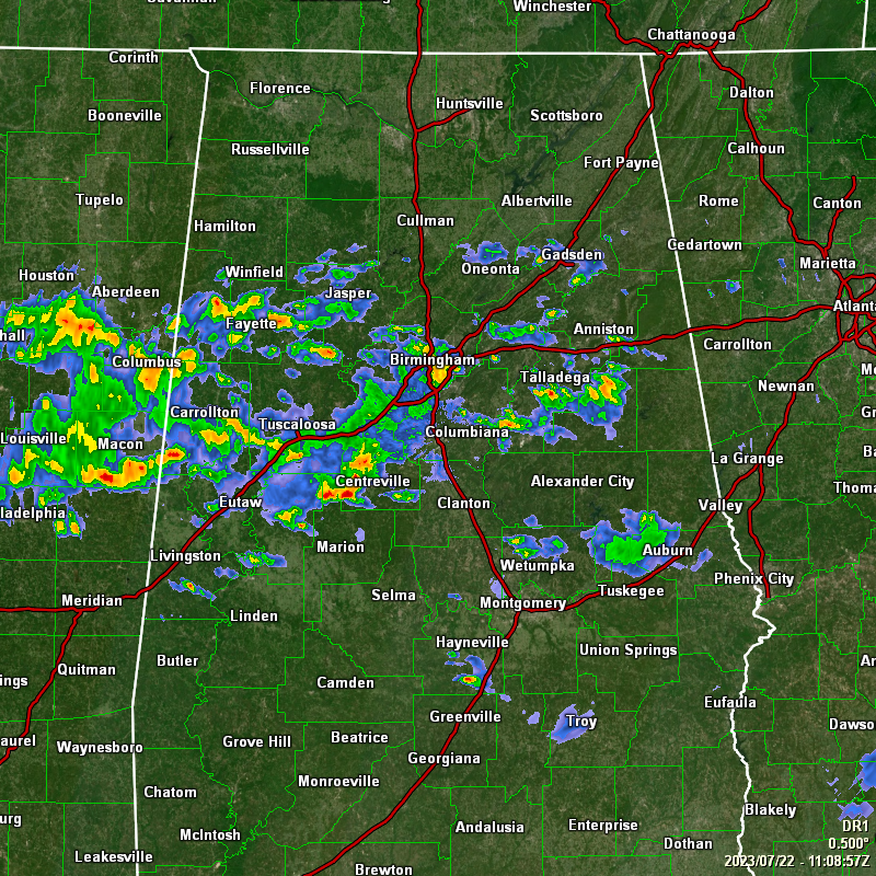
We’re starting off this morning (6:08 am) with scattered showers and storms slowly moving eastward across the central portions of Central Alabama. This activity is associated with a boundary that will be pushing slowly southward through the day. Rain and storms will be likely along and ahead of the boundary, but as it passes by, drier air will move in and quickly bring those rain chances to an end. A few strong storms will be possible ahead of the boundary, and a Marginal Risk is up for locations along and south of a line from Livingston to Clanton to Roanoke. Highs in the lower 80s to the lower 90s.
Much of Central Alabama will remain dry on Sunday, as the boundary will be stuck over the southern portions of the area. The higher rain chances will be along and south of I-85, while only an isolated shower or two will be possible south of the I-20 corridor. Highs in the mid 80s to the lower 90s.
An upper trough will be working its way southward on Monday that will continue to send us drier air into the area, which will keep heat index values closer to the actual temperature. Skies will be mainly sunny with highs in the upper 80s to the lower 90s.
Much of the same on Tuesday, as we’ll have plenty of sunshine and lower humidity. Highs in the upper 80s to the mid 90s.
On Wednesday, the trough will move eastward and will allow for more moisture-rich air to start moving into Central Alabama. Nearly everyone will stay dry, but an isolated shower or two can’t be ruled out. Humidity will start rising, so get ready for the mugginess to return. Highs in the lower to mid 90s.
Thursday will feature plenty of sunshine, but it will be hot and humid. There will be a small chance of a few isolated to scattered afternoon showers and storms. Highs in the lower to mid 90s.
And at the end of the forecast period on Friday… We’ll remain in the same pattern with mostly sunny skies and a chance of isolated to scattered afternoon showers and storms. Highs in the lower to mid 90s.

We have two areas out in the Atlantic we are watching. Tropical Storm Don is pestering the fish out there just over 600 miles south-southeast of Cape Race, Newfoundland. Winds are at 60 mph, and some strengthening is possible today. A turn to the north is expected later today, followed by a northeastward motion on Sunday, and weakening is forecast to begin by tonight or Sunday morning. Don is expected to become a post-tropical cyclone on Sunday or Sunday night.
Invest 95L is located between the Cabo Verde Islands and the Lesser Antilles, and it continues to show that it is gradually becoming organized. Some additional gradual development is anticipated, and this system will likely become a tropical depression by early next week while it moves westward across the tropical Atlantic. Many of the models will keep this activity moving nearly due west and staying well south of Cuba, Haiti, Puerto Rico, and the Dominican Republic. At this point, models are keeping this below hurricane-strength.
On This Day In Weather History: 1918 – A single bolt of lightning struck 504 sheep dead in their tracks at the Wasatch National Forest in Utah. Sheep often herd together in storms, and as a result the shock from the lightning bolt was passed from one animal to another.
Category: Alabama's Weather, ALL POSTS, Severe Weather, Tropical, Weather Xtreme Videos
About the Author (Author Profile)
Scott Martin is an operational meteorologist, professional graphic artist, musician, husband, and father. Not only is Scott a member of the National Weather Association, but he is also the Central Alabama Chapter of the NWA president. Scott is also the co-founder of Racecast Weather, which provides forecasts for many racing series across the USA. He also supplies forecasts for the BassMaster Elite Series events including the BassMaster Classic.Subscribe
If you enjoyed this article, subscribe to receive more just like it.


