Midday Nowcast: Increasing Rain Chances Rest of Week
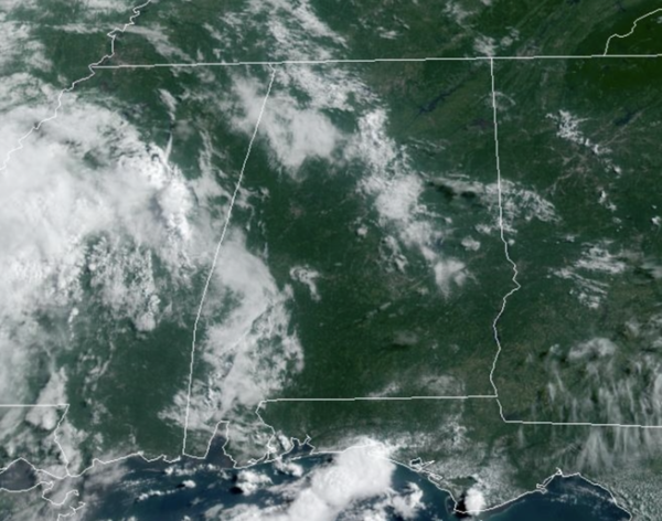
HAPPY HUMP DAY: A hot Wednesday across Alabama with highs in the low to mid 90s under a mix of sun and clouds. Moisture levels are on the rise, and a few scattered showers and storms this afternoon, mainly across the west and southwestern counties of the state.
TO OUR WEST: The heat dome is building again across Texas, the Southern Plains, and into the Mississippi Valley. Alabama will stay on the edge of the ridge…THE RING OF FIRE…and our rain chances will be on the increase as we are likely to see some clusters of thunderstorms roll into the state around the edge of the ridge through the weekend.
AIR YOU CAN WEAR: Moisture levels surge the next few days, and dew points are likely to be in the mid to upper 70s…yuck!!! That means our rain chances are on the rise, and we will see scattered to numerous shower and storms develop each day, but also we will keep an eye on the potential of those thunderstorm clusters. Rain chances will be in the 50%-60% range for much of Alabama. Expect partly sunny days with highs in the low to mid 90s. This pattern will persist through the weekend. It won’t rain every where each day, but each day, the radar will be active with rain and storms…keep the umbrella close.
NEXT WEEK: The ridge to the west will intensify and expand east, meaning our temperatures will be climbing higher…by next week, mid to upper 90s are expected across Alabama. With high dew point and hot temperatures, are are likely to see another round heat alerts across Alabama as heat index values will likely exceed the 105° danger range.
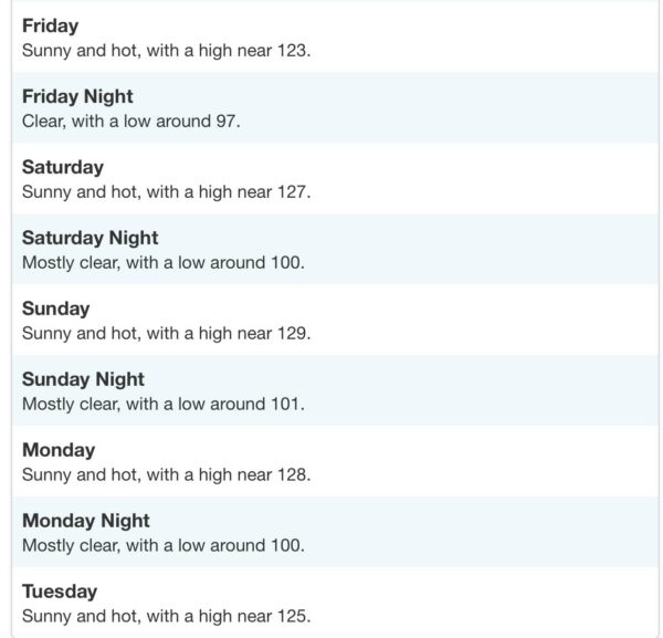
SEVERE BLISTERING HEAT: This weekend will be hot in Alabama as the upper-ridge strengthen, but nowhere near the forecast for Death Valley, CA. Highs could approach 130° this weekend & early next week with nighttime lows not falling below 100°! Hottest temperature ever recorded on Earth, 134° happened in Death Valley in 1913.
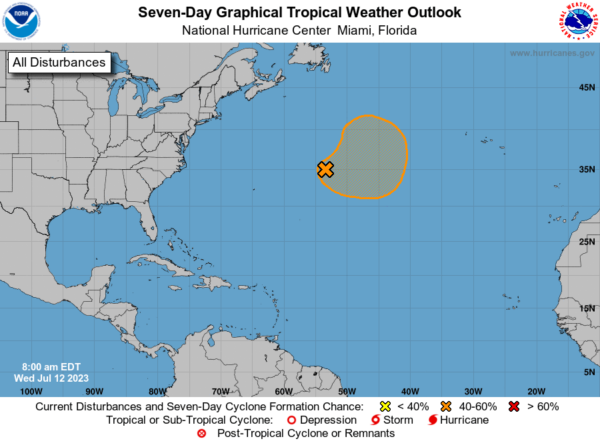
IN THE TROPICS: An area of low pressure located more than 500 miles east-northeast of Bermuda continues to produce disorganized showers and thunderstorms well to the south of its center. Environmental conditions are forecast to be marginally conducive for some development of this system, and a subtropical or tropical depression or storm could form during the next few days while the system moves generally eastward. By the weekend, the low should turn northward bringing the system over cooler waters, potentially limiting additional development. Formation chance through 48 hours…medium…40 percent. Formation chance through 7 days…medium…50 percent.
BEACH FORECAST CENTER: Get the latest weather and rip current forecasts for the beaches from Fort Morgan to Panama City on our Beach Forecast Center page. There, you can select the forecast of the region that you are interested in visiting.
WORLD TEMPERATURE EXTREMES: Over the last 24 hours, the highest observation outside the U.S. was 121.1F at Basrah-Hussen, Iraq. The lowest observation was -96.5F Vostok, Antarctica.
CONTIGUOUS TEMPERATURE EXTREMES: Over the last 24 hours, the highest observation was 118F at Death Valley, CA. The lowest observation was 27F at Copper Basin, ID.
Category: Alabama's Weather, ALL POSTS


