Breaking Down the Severe Weather Threat for Alabama Today
Things are quiet across Alabama weather-wise on this July Sunday morning. Skies are partly sunny to mostly cloudy. There is a little bit of fog at Montgomery and Prattville. Temperatures are in the 70s across the state except for a few upper 60s in the Tennessee Valley and Northeast Alabama. There are a few very light showers showing up on radar across parts of Coosa, Tallapoosa and Clay Counties.
A few showers will likely form this morning across Central and Southwest Alabama.
At the surface, a low-pressure system is situated over the Great Lakes region, with a frontal boundary extending southwest towards Arkansas and back into the Texas Panhandle. This boundary is anticipated to gradually move southeastward, progressing through much of central Alabama tonight and into Monday. It should stall over South or South Central Alabama on Monday.
In the upper atmosphere, there is a broad trough extending from central Canada into the eastern United States, while high pressure dominates the western United States.
Over the short term, the upper-level low-pressure system will deepen as it moves eastward, resulting in a shift from west-northwest flow to northwest flow over Alabama. Disturbances ahead of the approaching surface boundary will trigger convection in the warm and humid air mass present across the Deep South.
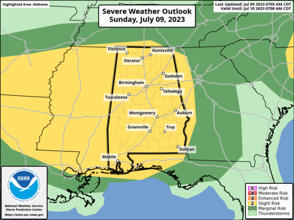
Conditions are favorable for severe weather across Alabama today. The SPC has posted a Day One Slight and Marginal Risk for all of the state except for the tiniest sliver of Northeast Jackson County. In fact, the only communities in Alabama not in the Slight Risk are Long Island and Bryant. And even they are in the marginal risk.
The player is on the field with a thunderstorm complex over southeastern Oklahoma, western Arkansas, and northeastern Oklahoma. It should weaken as it moves eastward, but it will become re-energized as it approaches western Alabama this evening, after 9 p.m.
Ahead of it, additional showers and storms will form by late afternoon over West Central and Northwest Alabama by 4-6 p.m., pushing east southeastward across the area.
There will be a decent amount of instability, with CAPE values running above 2,500 joule. There will be sufficient bulk shear, running around 40 knots. This means strong, organized thunderstorm updrafts. The only limiting factor there is mediocre lapse rates in the 4.9-5.9 C/km range.
In addition, early storms during the late afternoon hours may limit instability from its full potential. Any thicker clouds today will help also.
The primary concern will be the potential for damaging straight-line winds, although there is also a possibility of localized heavy rainfall due to elevated moisture ahead of the boundary. The Weather Prediction center does have a large part of the area in their Excessive Rainfall Outlook which works much like an SPC Outlook.
The HRRR does develop a small surface low over Central Mississippi that tracks eastward into West Central Alabama by late evening. There could be just enough helicity there for a quick spin-up tornado in West Central Alabama. I can’t rule it out completely. Not likely certainly, but possible.
Stay informed and stay safe this afternoon and tonight! Make it a priority to monitor the weather regularly. We will have frequent updates throughout the day and night. Have a reliable weather app or a NOAA weather radio on hand to receive timely warnings.
Category: Alabama's Weather, ALL POSTS, Severe Weather


