Saturday Weather Briefing — Sizzling Heat with a Few Strong to Severe Storms
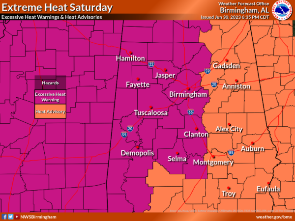
EXCESSIVE HEAT WARNING & HEAT ADVISORIES
An Excessive Heat Warning remains in effect until 9 pm tonight for locations along and west of I-65, as heat index values will be topping out in the 108º-113º range. A Heat Advisory continues until 9 pm tonight for the eastern half of the area, as heat index values will range from 104º to 108º.
Extreme heat and humidity will significantly increase the potential for heat related illnesses, particularly for those working or participating in outdoor activities. Drink plenty of fluids, stay in an air-conditioned room, stay out of the sun, and check up on relatives and neighbors. Young children and pets should never be left unattended in vehicles under any circumstances.
THE FIRST WEEKEND OF JULY
Wow! This year has flown by. For today, hot and humid will be the story, but we’ll have enough instability, along with boundaries moving in from the north, that scattered showers and storms will be possible during the afternoon and evening. A few storms may become strong to severe with gusty winds and hail as the main threats.
As of 10 pm Friday night, SPC has all the Tennessee Valley and the top row of counties in the northern parts of Central Alabama in a Slight Risk, while much of the rest of the area is in a Marginal Risk. Highs ranging from 96º to 101º.
Sunday will be another hot day, but we will start to see a slow decline in these scorching temperatures. Heat Advisories may be extended in size and time, but we might not see another Excessive Heat Warning. We’ll have a small chance of scattered afternoon to evening showers and thunderstorms with highs ranging from 94º to 99º.
MONDAY & INDEPENDENCE DAY
The upper ridge that has been in control of our weather and causing the “heat bubble” over the area will be breaking down as a trough begins to approach the Tennessee Valley on Monday. Scattered to numerous showers and storms will be possible with highs in the lower to mid 90s. July 4th looks to be pretty much the same with the daytime highs dipping a little cooler. Scattered to numerous showers and storms will be possible with highs in the upper 80s to the mid 90s.
THE 3-DAY WORK WEEK
Another weak trough will approach and move into the Tennessee Valley on Wednesday, that will bring an increase to our rain chances, as scattered to numerous showers and storms will be likely. Highs in the upper 80s to the mid 90s. Not much change in the thinking for Thursday and Friday, as scattered to numerous showers and storms will be likely, especially for the afternoon to evening hours. Highs on both days will be in the upper 80s to the lower 90s.
THE TROPICS
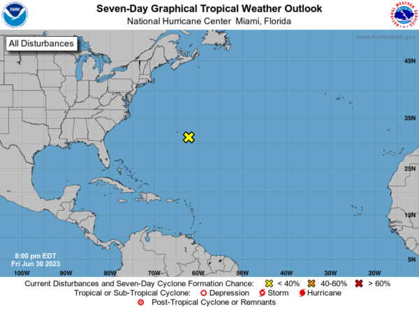
As of 7 pm Friday Evening, A broad area of low pressure continues to produce disorganized showers and thunderstorms about a hundred miles to the east-southeast of Bermuda. The system is forecast to move generally north-northeastward at about 10 mph during the next couple of days, and development into a tropical or subtropical cyclone is not expected due to strong upper-level winds.
* Formation chance through 48 hours…low…near 0 percent.
* Formation chance through 7 days…low…near 0 percent.
BEACH FORECAST CENTER
Get the latest weather and rip current forecasts for the beaches from Dauphin Island, AL, to Panama City Beach, FL, on our Beach Forecast Center page. There, you can select the forecast of the region that you are interested in.
ON THIS DAY IN WEATHER HISTORY
1989 – Showers and thunderstorms associated with the low pressure system which was once Tropical Storm Allison continued to drench parts of Mississippi, Louisiana and eastern Texas. Late night thunderstorms produced 12.58 inches of rain at Biloxi MS in six hours, and 10.73 inches at Gulfport MS. Flooding in Mississippi over the first six days of the month caused 55 million dollars damage.
ADVERTISE ON THE BLOG!
Don’t miss out! We can customize a creative, flexible, and affordable package that will suit your organization’s needs. Contact Bill Murray at (205) 687-0782.
E-FORECAST
Get the Alabama Wx Weather Blog’s Seven-Day Forecast delivered directly to your inbox by email twice daily. It is the most detailed weather forecast available in Central Alabama. Subscribe here… It’s free!
CONNECT WITH THE BLOG ON SOCIAL MEDIA
You can find the Alabama Wx Weather Blog on Facebook and Twitter.
WEATHERBRAINS
If you are crazy about weather, this is THE podcast for you! Listen to the latest released episode each Tuesday, or catch up on any episodes that you have missed. The WeatherBrains crew includes your host, James Spann, plus other notable geeks like Troy Kimmel, Bill Murray, Rick Smith, James Aydelott, Jen Narramore, Dr. Neil Jacobs, and Dr. Kim Klockow-McClain. They bring together a wealth of weather knowledge and experience for another fascinating podcast about weather. Available at WeatherBrains.com, or on Apple Podcasts, Google Podcasts, Spotify, or Stitcher.
Category: Alabama's Weather, ALL POSTS, Severe Weather, Tropical, Weather Xtreme Videos


