Monday Morning Forecast Discussion
NO VIDEO THIS MORNING BECAUSE OF SEVERE WEATHER COVERAGE LAST NIGHT
Another active night across Alabama and the Deep South again last night, but hopefully our extended anomalous period of severe weather is winding down. Just in time for the tropical Atlantic to throw us some anomalous activity in the form of an early season storm in the main development region of the Atlantic, something we don’t usually see til July or August. In fact, if it happens, we have never seen a storm like this so early in the season. Especially warm ocean temperatures are to blame.
SUNDAY NIGHT SEVERE: An approaching upper level disturbance triggered severe thunderstorms in an unstable environment across Mississippi and Alabama overnight. The storms were aided by an unusual low level jet for mid-June, but they mostly stayed well behaved. Tornado watches were issued for the evening and overnight hours of western Alabama and points west ,but they generally were not needed. The storms rumbled through without much damage, but heavy rain, lightning, and gusty winds generally.
PRETTY MUCH DODGED A BULLET: Damage was reported from around Owens Crossroads in Madison County where several large trees were uprooted and a porch column was torn off a house. A tree also fell on a vehicle. There were also reports of quarter sized hail. In west central Alabama, a large tree was blown down and completely was blocking highway 171 at the Tuscaloosa/Fayette County line nears Moore’s Bridge around 10 p.m. There was tornado damage in southeastern Mississippi near Bay Springs. That area around Laurel always seems to get it.
FOR YOUR MONDAY: We are starting the day mostly cloudy, warm, and humidly across North and Central Alabama. Some straggling shower are making a run for the Georgia border and will be completely out of our state by 8-9 a.m. Clouds will be breaking up from the west during the day, but it may be late afternoon before sunshine returns for eastern sections. We have an upper low to our north, and that could set off a few showers this afternoon, but coverage will be light and spotty. Tonight will feature some wraparound clouds from the low, and a chance of a stray overnight shower, with lows in the 60s after today’s highs in the middle 80s generally.
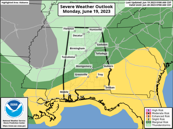
SPC SAYS: Here is the day one severe weather outlook:
TUESDAY: The upper low will be spinning away to our north on Tuesday, with wraparound clouds and convective showers that sort of look like a late winter/early spring system. But temperatures will be in the 80s, so no fears about having winter flashbacks. There is some discussion about whether we could still have severe weather on Tuesday, but if we do, it will be over far South Alabama.
REST OF THE WORK WEEK: Showers and storms will remain in the forecast Wednesday and Thursday with the upper low in the proximity. Seemingly, the severe weather threat should be lessening. Things will be a little cooler Wednesday and Thursday, with highs in the upper 70s in North Alabama and lower 80s across the central part of the state.
WEEKEND OUTLOOK: Rain chances seem to decrease by the weekend, setting the stage for a nice introduction to summer with highs around 90 and lows near 70. Only widely scattered afternoon and evening storms. Just perfect for summer.
TROPICS: A tropical depression is expected to form today or tomorrow in the Atlantic around 40 West, an unusual place to see a depression in June. There is some uncertainty in its forecast intensity and track. It could recurve to the north or if it is weaker, it could move toward the northern Antilles.
BEACH FORECAST CENTER: Get the latest weather and rip current forecasts for the beaches from Dauphin Island, AL, to Panama City Beach, FL, on our Beach Forecast Center page. There, you can select the forecast of the region that you are interested in.
ON THIS DAY IN WEATHER HISTORY: 1835 – Tornado occurred at New Brunswick, New Jersey killing 5 people. It is regarded to be the worst tornado in Garden State history. Debris falling from the tornado was reported as far away as Manhattan. 4 people died in the twister and many others were injured. A tornado in the same location today would cause tremendous destruction. The tornado was the first to be widely studied by scientists in the budding discipline of meteorology. Other smaller tornadoes were reported at Patterson, New Jersey, Kinderhook, New York, and Pine Plains, New York.
ADVERTISE ON THE BLOG! Don’t miss out! We can customize a creative, flexible, and affordable package that will suit your organization’s needs. Contact Bill Murray at (205) 687-0782.
E-FORECAST: Get the Alabama Wx Weather Blog’s Seven-Day Forecast delivered directly to your inbox by email twice daily. It is the most detailed weather forecast available in Central Alabama. Subscribe here… It’s free!
CONNECT WITH THE BLOG ON SOCIAL MEDIA: You can find the Alabama Wx Weather Blog on Facebook and Twitter.
WEATHERBRAINS: If you are crazy about weather, this is THE podcast for you! Listen to the latest released episode each Tuesday, or catch up on any episodes that you have missed. The WeatherBrains crew includes your host, James Spann, plus other notable geeks like Troy Kimmel, Bill Murray, Rick Smith, James Aydelott, Jen Narramore, Dr. Neil Jacobs, and Dr. Kim Klockow-McClain. They bring together a wealth of weather knowledge and experience for another fascinating podcast about weather. Available at WeatherBrains.com, or on Apple Podcasts, Google Podcasts, Spotify, or Stitcher.
Category: Alabama's Weather, ALL POSTS, Severe Weather


