Counties Starting to be Cleared from the Watch; Latest Thinking
The NWS in Huntsville has cleared all their counties from the tornado watch. The severe weather threat is over for Colbert, Franklin, Lauderdale, and Lawrence Counties.
Birmingham has cleared Fayette, Lamar, Marion, Walker, and Winston Counties. The watch continues for Bibb, Dallas, Greene, Hale, Marengo, Perry, Pickens, Sumter, and Tuscaloosa Counties till 8:00 AM CDT. The threat should mostly be over by then.
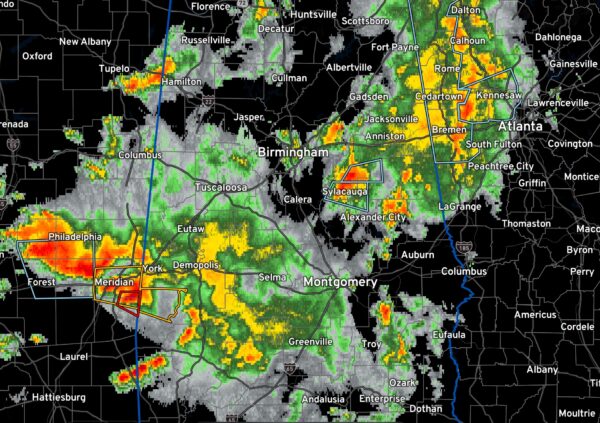
Right now, the strongest thunderstorm is currently in Talladega County, with another small updraft strengthening in Bullock County. The storm moving into Clay County could have gusty winds and small hail.
From Alex Sizemore at the NWS: “The convection in east central MS is essentially acting as a barrier for more favorable low-level conditions to advect farther northeast into Central Alabama, which is a good thing considering the LLJ runs right up I-20 through BHM. They should continue to drift slowly southeast along the CAPE gradient angled toward the Mobile area, being fed by the LLJ.”
“From a parameter space perspective we’re not out of the woods just yet. I’d say the threat overall is low, mainly due to a messy SBCAPE enviroment, and the convective evolution over the past couple of hours helps confirm that. Shear is still quite favorable. Nonetheless, counties will be cleared from the watch as the boundary pushes southeast. With that being the case, many counties will not go all the way through 8 AM. If the convection totally craps out we can make a judgement call then as well. All things considered, it appears the greatest severe threat (for Central Alabama) is currently Pickens down through Dallas Counties.”
Thanks Alex!
The storm southeast fo Meridian has a tornado warning on it. It will move east southeast into Choctaw Counties. The possible tornado will move near Lisman and Butler. The NWS Mobile has issued a severe thunderstorm warning for Choctaw County.
Category: Alabama's Weather, ALL POSTS, Severe Weather


