Storms Increasing for North and Central Alabama
Storms are now firing over the North and Central parts of Alabama, in addition to the active storms over South Alabama.
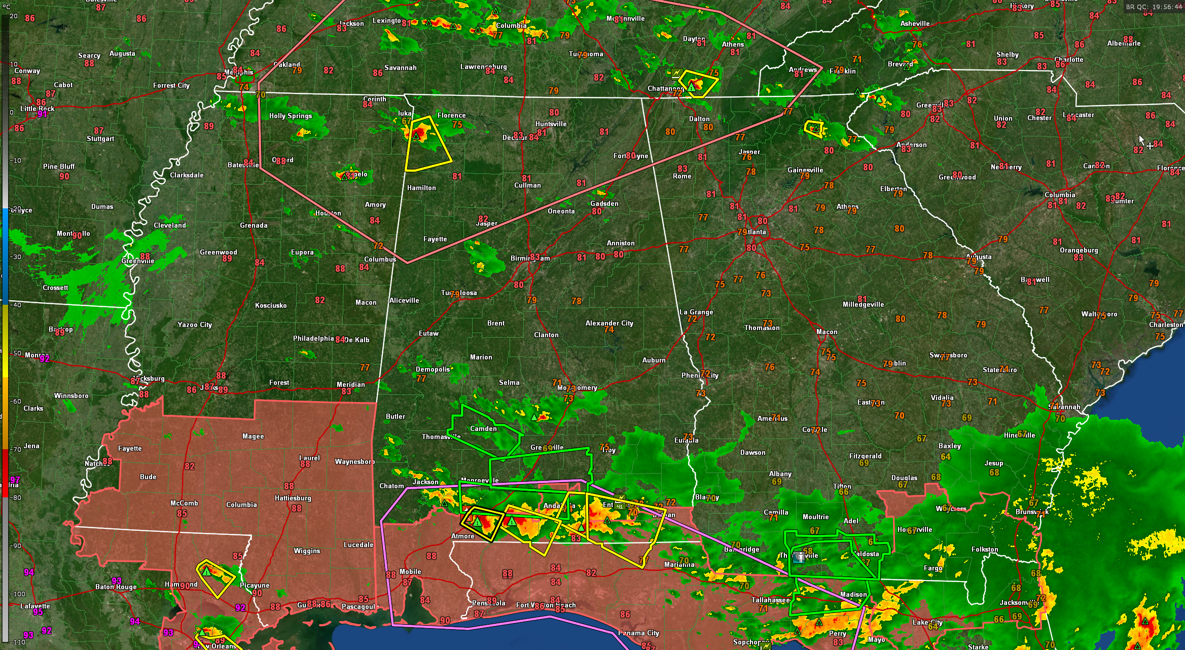
A new severe thunderstorm warning was just issued for parts of Franklin and Colbert Countie sin Northwest Alabama. It is in effect until 3:30 pm. Large hail and damaging winds are the main threats. Right now that is the only storm in North Alabama. It is pushing southeast in the general direction of Phil Campbell. It will mainly affect Russellville, Isbell, and Hodges over the next hour. Wind is the biggest threat for now. Hail could reach 1 inch. It has good CAPE of around 2700 joules to work with. It will encounter increasingly favorable bulk shear as it drops southward, so it will probably hold together for awhile. Max winds are about 47 knots 3,000 feet off the surface. Getting 30 lightning strikes per minute.
Other storms are in North central Alabama along the Walker and Tuscaloosa County line. Another storm has developed north of Gadsden in Etowah County. These are a ways from being severe but we will be watching them.
Additional storms are lining up over Tennessee as well. These will drop south and southeastward into Alabama, northern Mississippi, and northern Georgia this afternoon.
The SPC issued a mesoscale discussion about an hour ago and they are not concerned enough to put up a watch based on current conditions. But the storms will still have the potential to pack a punch as they grow this afternoon with damaging winds and some large hail.
In South Central Alabama, storms are occurring generally in the US-80 Corridor from Linden in Marengo County to to Hayneville to south of Montgomery. They are below severe limits, but as afternoon heating continues they may get stronger.
South Alabama is still plagued with big storms for a second straight but with the jet stream located over them. These storms extend from Choctaw and Washington Counties southeast through Clarke and southern Monroe Counties the across Escambia, southern Conecuh and Covington Counties into much of Coffee County southwest of Andalusia. Several of them are severe thunderstorm warned. There are a couple of big flash flood warnings as well.
Out to our west, Oklahoma and Texas are bracing for a bad late afternoon and evening of severe weather. The SPC has a moderate risk posted and tornado watches are in effect. The SPC warns that there will be widespread large hail and scattered very large hail events to 5 inches in diameter as well as wind gusts to 90 mph, as well as a few tornadoes. Storms are already starting to fire over western Oklahoma.
Category: Alabama's Weather, ALL POSTS, Severe Weather
About the Author (Author Profile)
Bill Murray is the President of The Weather Factory. He is the site's official weather historian and a weekend forecaster. He also anchors the site's severe weather coverage. Bill Murray is the proud holder of National Weather Association Digital Seal #0001 @wxhistorianSubscribe
If you enjoyed this article, subscribe to receive more just like it.


