Unsettled Weather Continues Across Alabama Today
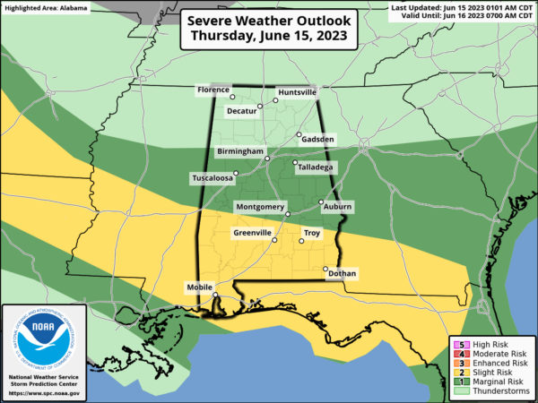
RADAR CHECK: We have a band of rain and strong, noisy thunderstorms across Central Alabama early this morning. Storms are producing torrential rain, some small hail, gusty winds, and very frequent lightning. Through the day today we project scattered to numerous showers and thunderstorms, and SPC has defined a “slight risk” (level 2/5) of severe storms south of a line from Linden to Fort Deposit to Eulfaula, and a “marginal risk” as far north as Fayette, Gardendale, and Heflin.
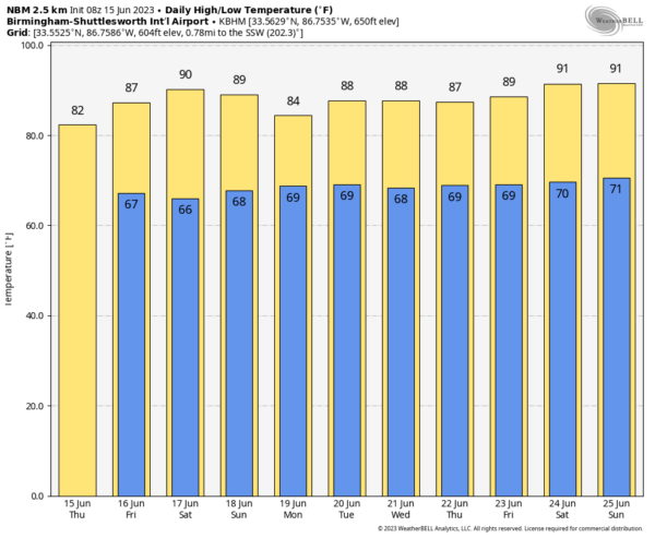
The main threats from heavier storms today will come from hail and strong winds; there is only a very low tornado probability over the southern quarter of the state. Understand it won’t rain all day, and some you will see some sun. The high this afternoon will be in the low to mid 80s.
We should mention a flash flood watch remains in effect for the southern 2/3 of Alabama today, basically from I-20 south. Storms will be very efficient rain producers.
TOMORROW AND THE WEEKEND: Thunderstorms should be fewer in number across Alabama tomorrow and Saturday as they become more scattered. But, where they form they could be strong and a decent part of the state is in a “marginal risk” (level 1/5) both days. Otherwise, expect a partly sunny sky with a high in the 88-92 degree range. On Sunday a disturbance will being an increase in the coverage of showers and storms. Still, not raining all day… but a few passing showers and thunderstorms are likely with a high in the 80s.
For now SPC has defined a severe weather risk Sunday for areas north and west of Birmingham… the main concern remains hail and strong winds.
NEXT WEEK: We will need to mention some risk of scattered showers and thunderstorms on a daily basis through the week, most active during the afternoon and evening hours. Highs will be in the 87-91 degree range most days… See the video briefing for maps, graphics, and more details.
TROPICS: The Atlantic basin remains quiet and tropical storm formation is not expected for the next seven days.
ON THIS DATE IN 1991: The second largest volcanic eruption of the 20th Century began as Mt. Pinatubo injected 15 to 30 million tons of sulfur dioxide 100,000 feet into the atmosphere. 343 people were killed in the Philippines as a result of the eruptions, and 200,000 were left homeless. Material from the explosion would spread around the globe, leading to climate changes worldwide as the sun’s energy was blocked out and global temperatures cooled by as much as one degree Fahrenheit. 1992 was globally one of the coldest since the 1970s.
Look for the next video update here by 3:00 this afternoon… enjoy the day!
Category: Alabama's Weather, ALL POSTS, Weather Xtreme Videos


