
Severe Weather Threat for Alabama Overnight
It’s a beautiful Sunday morning across Alabama. Clouds are still pretty thick in the eastern portion of the state where the last few slightly tardy showers are exiting the state into Georgia. Temperatures are in the 70s areawide but approaching 80F in South Central Alabama in places like Demopolis.
Most of the day should be dry and hot with only 3-4 isolated storms able to form. Highs will range from 87-90F with the hottest readings down along US-80 from York to Demopolis to Selma and Montgomery.
A cold front extends from a low over northern Indiana back to northern Missouri. Surface lows over Central Missouri will congeal into one main low by afternoon that will push into Central Indiana, lifting a warm front through the Appalachians. A warm, and moist atmosphere will be in place in the broad warm sector from southern Indiana into Georgia and westward all the way to Texas and Oklahoma.
The initial focus will be across Kentucky and northern Tennessee early this afternoon. But by 4-6 p.m., a large line of storms will form ahead of the main cold front across western Tennessee back into northwestern Mississippi. This will be the focus of our severe weather tonight as it sweeps east southeastward into Alabama by 8-9 p.m. Storms should reach the I-65 Corridor by 10-11 p.m. and then sink slowly southward through the overnight hours.
By 5 a.m., the main activity should be south of Montgomery with a few leftover showers and storms over South Central Alabama. All of the activity should be out of Alabama by 10 a.m. Widespread strong to severe storms will be likely Monday afternoon over South Alabama, but North and Central Alabama should be dry.
More storms may move into the northern half of the state Tuesday morning.
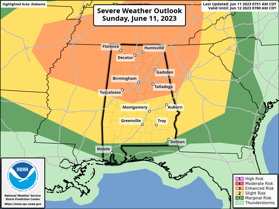
The SPC has issued an enhanced risk (their level 3 out of 5) for the northern half of Alabama with a slight risk (level 2 out of 5) for all but coastal sections. Even Mobile and Baldwin Counties are in a marginal risk (1/5).
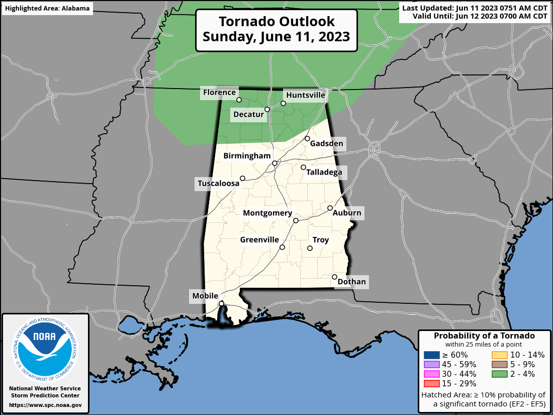
We note that the is a 2% tornado risk for the northern third of the state. So tornadoes are possible for area generally north of US-278 from Hamilton to Cullman to Gadsden. I think we will see a couple of tornadoes this evening over westerns Tennessee and northern Mississippi. I am basing that on point forecast soundings from the HRRR which show plenty of CAPE and about 150 m2/s2 of storm relative helicity. This threat could translate over into extreme northern Alabama as well.
The main threat however will be from damaging winds and even some hail. There could be some significant hail, perhaps as large as 1.75 inches over northern Alabama. That’s golf ball size. But again, damaging winds will be the main threat.
We remind you to take severe thunderstorm warnings seriously. Falling trees claim too many lives of people driving during the storm or when they fall on houses.
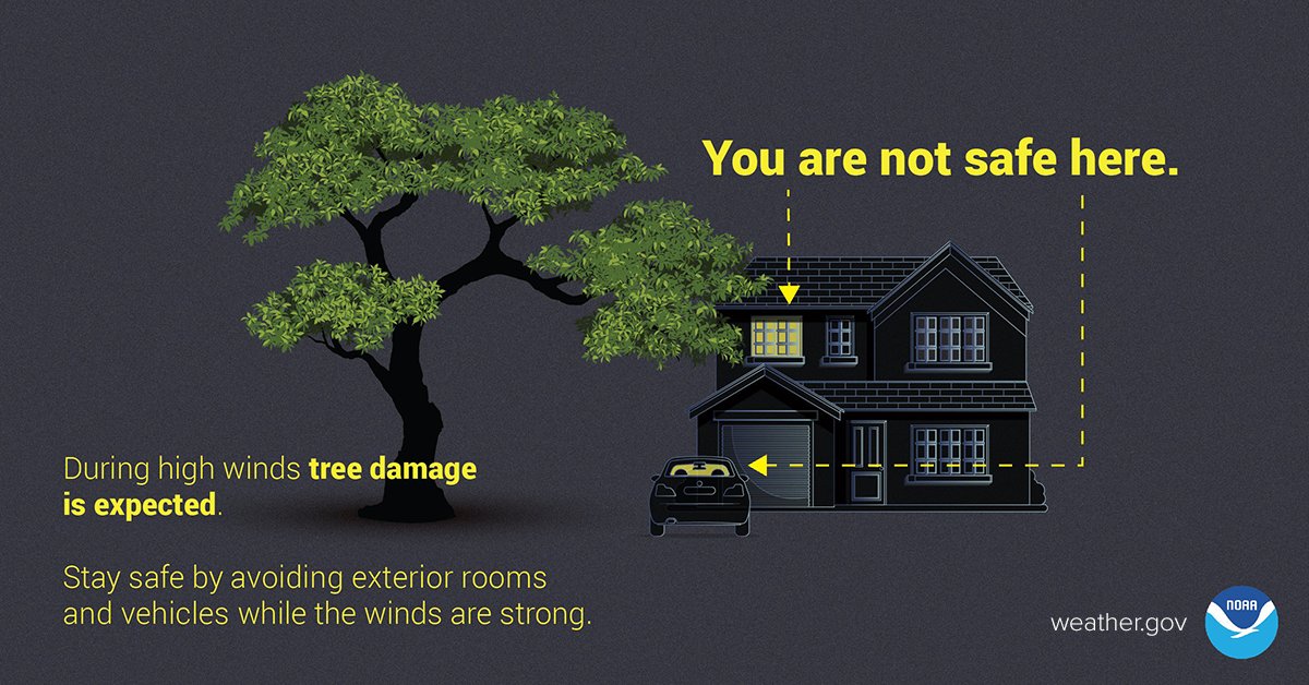
This will be one of those nights when you want to have a reliable way of receiving warnings that will wake you after you go to bed. Make sure your NOAA weatheradio is set to alarm. And go through sensible precautions if a severe thunderstorm warning is issued for you: gather everyone in the lowest level of your home, in a central room. Avoid vehicles and exterior rooms while the winds are strong.
We will bring you updates throughout the afternoon as the storm system organizes. Of course, we will have frequent updates through the evening and overnight as the storms progress.
Category: Alabama's Weather, ALL POSTS, Severe Weather
About the Author (Author Profile)
Bill Murray is the President of The Weather Factory. He is the site's official weather historian and a weekend forecaster. He also anchors the site's severe weather coverage. Bill Murray is the proud holder of National Weather Association Digital Seal #0001 @wxhistorianSubscribe
If you enjoyed this article, subscribe to receive more just like it.


