Another Hot, Humid Day; A Few Storms This Afternoon
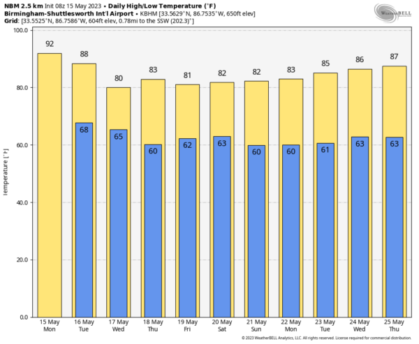
SUMMER PATTERN CONTINUES: Alabama’s weather won’t change much today; expect a high in the 88-92 degree range this afternoon with a few pop-up showers or storms this afternoon and early tonight. Chance of any one spot seeing rain today is around 30 percent, and most of the showers will come from 2:00 until 9:00 p.m.
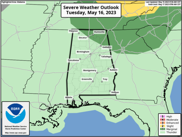
We expect an increase in the coverage of showers and thunderstorms across Alabama tomorrow ahead of a surface front, and SPC has the northeast corner of the state in a “marginal risk” (level 1/5) of severe storms.
Heavier thunderstorms across Northeast Alabama tomorrow could produce hail and strong winds; there is no tornado threat. Otherwise, tomorrow will be occasionally cloudy with scattered to numerous showers and storms; the high will be in the mid to upper 80s.
WEDNESDAY THROUGH FRIDAY: Heat levels come down over the latter half of the week, with highs closer to 80 degrees. And, the highest coverage of showers and storms will shift into South Alabama as the surface front sags southward. Still, a few widely scattered showers can’t be ruled out across the northern half of the state on these three days.
THE ALABAMA WEEKEND: A more meaningful front will bring the chance of a few passing showers or storms Saturday (no all-day rain), followed by a dry, continental airmass Sunday with lower humidity and a sunny sky. Highs will remain close to 80 degrees, which is a bit below average for mid to late May in Alabama.
NEXT WEEK: Dry air stays in place for the first half of the week; a few scattered showers could return by Thursday and Friday. Highs will be generally in the 80s, with lows in the 60s. See the video briefing for maps, graphics, and more details.
ON THIS DATE IN 1957: An F4 tornado killed 20 people in Silverton, Texas. A 5,000-pound gasoline storage tank was reportedly carried 1.5 miles and dropped into a lake. Residents said the tornado “looked like red sand, boiling and rumbling.
ON THIS DATE IN 1972: The worst ice jam flooding of memory for long-time residents took place along the Kuskokwim River and Yukon River in Alaska. It was the first time since 1890 that the two rivers “flowed as one.” The towns of Oscarville and Napaskiak have been entirely inundated.
Look for the next video briefing here by 3:00 this afternoon… enjoy the day!
Category: Alabama's Weather, ALL POSTS, Weather Xtreme Videos


