Warm, Humid Weather Continues With Scattered Storms
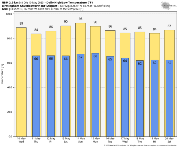
SUMMER PATTERN STAYS IN PLACE: Look for highs mostly in the mid 80s across Alabama through Friday, about 5 degrees above average for mid-May. The weather will remain warm and humid with a mix of sun and clouds daily along with random, scattered showers and thunderstorms. Most of them (but not necessarily all) will come during the afternoon and evening hours, from roughly 2:00 until 9:00 p.m.
Thanks to high precipitable water values, they will be very effective rain producers and a few spots will see heavy rain. But, others won’t see a drop… so it goes in this summer-like pattern.
The chance of any one spot getting rain through Friday is now 60-70 percent, but it certainly won’t rain all day. Stronger storms will produce gusty winds, small hail, and lots of lightning.
THE ALABAMA WEEKEND: The upper ridge over the region will strengthen, meaning higher heat levels and fewer showers. Afternoon highs will be close to 90 degrees both days, and the risk of any one community seeing a shower drops to 20-30 percent.
NEXT WEEK: The warm, humid, soupy pattern continues across Alabama and the Deep South Monday and Tuesday with scattered showers and storms… we still see trends in global models suggesting lower humidity values over the latter half of the week with fewer showers; See the video briefing for maps, graphics, and more details.
ON THIS DATE IN 2010: On this day, Oklahoma experienced its largest tornado outbreak since May 3, 1999. Fifty-five twisters tore through the state, including two rated EF4. The EF4 storms took three lives and injured 81 people. Ironically, both EF4 tornadoes struck Norman, Oklahoma, home of the Storm Prediction Center and the National Severe Storms Laboratory. Fourteen additional tornadoes hit Oklahoma during May 11-13.
Look for the next video briefing here by 3:00 this afternoon… enjoy the day!
Category: Alabama's Weather, ALL POSTS, Weather Xtreme Videos


