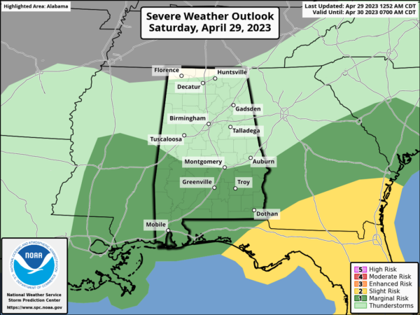
Showers & Storms Move in Later Today; A Few Strong Storms Possible
THIS WEEKEND
We’ll start off with some patchy fog across portions of the area, but that will lift quickly this morning. After that, we’ll have a surface low moving across the extreme southern parts of the state that will bring some rain and storms to South Alabama, but another round of rain and storms will develop this afternoon to our west and will begin to move into the area by late afternoon and into the evening.
A few strong storms will be possible, and a marginal risk is up for the southern quarter of Central Alabama. Highs in the upper 70s to the lower 80s. Rain will be moving out of the area on Sunday morning, and that will leave us with clearing skies, cooler temperatures, and breezy conditions during the afternoon. Highs will be in the upper 60s to the upper 70s.
NEXT WEEK
Much of the work week ahead will be very nice and mild. Monday will be sunny and breezy at times as winds will be out of the west averaging around 5 to 15 mph, with gusts up to 30 mph. Highs in the upper 60s to the mid 70s. Same story, but just less wind on Tuesday. Sunny skies and highs in the lower 70s to the lower 80s. Sunshine will once again be in full force on Wednesday, with highs in the mid 70s to the lower 80s. We’ll have sunny skies to start the day on Thursday, but there will be a short wave heading in our direction that will bring a chance of showers and storms to the area during the nighttime and overnight hours. Highs in the upper 70s to the mid 80s. And at the end of the forecast period on Friday… We’ll continue to have a chance of showers and storms through the day. At this point, severe weather doesn’t look likely, but we’ll keep an eye on it. Highs in the upper 70s to the mid 80s.
ON THIS DAY IN WEATHER HISTORY
1963 – A tornado, as much as 100 yards in width, touched down south of Shannon, MS. The tornado destroyed twenty-seven homes along its eighteen-mile path, killing three persons. Asphalt was torn from Highway 45 and thrown hundreds of yards away. Little rain or snow accompanied the tornado, so it was visible for miles.
BEACH FORECAST
Get the latest weather and rip current forecasts for the beaches from Dauphin Island, AL, to Panama City Beach, FL, on our Beach Forecast Center page. There, you can select the forecast of the region that you are interested in.
ADVERTISE ON THE BLOG
Don’t miss out! We can customize a creative, flexible, and affordable package that will suit your organization’s needs. Contact Bill Murray at (205) 687-0782.
E-FORECAST SIGN UP
Get the Alabama Weather Blog’s Seven-Day Forecast delivered directly to your inbox by email twice daily. It is the most detailed weather forecast available in Central Alabama. Subscribe here… It’s free!
CONNECT WITH THE BLOG ON SOCIAL MEDIA
You can find the AlabamaWx Weather Blog on Facebook and Twitter.
WEATHERBRAINS
If you are crazy about weather, this is THE podcast for you! Listen to the latest released episode each Tuesday, or catch up on any episodes that you have missed. The WeatherBrains crew includes your host, James Spann, plus other notable geeks like Troy Kimmel, Bill Murray, Rick Smith, James Aydelott, Jen Narramore, Dr. Neil Jacobs, and Dr. Kim Klockow-McClain. They bring together a wealth of weather knowledge and experience for another fascinating podcast about weather. Available at WeatherBrains.com, or on Apple Podcasts, Google Podcasts, Spotify, or Stitcher.
Category: Alabama's Weather, ALL POSTS, Severe Weather, Weather Xtreme Videos


