Saturday Weather Briefing Video: Nice Weather for A Busy Weekend
Showers and storms moved across Alabama overnight, but the good news was that they weren’t severe. They did produce plenty of lightning, heavy rain, and gusty winds, but the only significant damage was some trees down near Bankston in Fayette County around 7:35 p.m. It was likely straight line winds, but could have been a quick spin-up tornado. Rainfall amounts were fairly light since the storms were moving at a pretty good clip. The storms were ahead of a cold front that is nearly out of Alabama early on this Saturday morning.
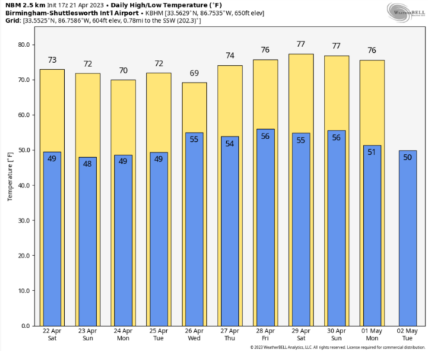
BUSY SATURDAY: Lots of things going on across North and Central Alabama on this April 22nd, including the annual A-Day spring football game at Tuscaloosa, racing at Talladega, the St. Elias Middle Eastern Food Festival, USFL games at Protective Stadium, Dogwood Festival, Magnolia Festival, and even a Mimosa Festival. The weather will be fine for all these events, so get out and enjoy! Skies will clear fairly quickly and temperatures will rise from the 40s and lower 50s into the lower and middle 70s this afternoon. We will drop back into the 40s overnight under partly cloudy skies.
RACE SUNDAY: Let ’em go, Harold! The weather will be fine for tomorrow’s GEICO 500 at NASCAR’s Biggest and Baddest Superspeedway. Expect a mix of clouds and sun, with afternoon readings topping out between 68-74F. We can’t rule out an overnight shower Sunday night, but the race teams will already be heading out to Dover by then. Sunday night lows will be in the 40s again.
START TO A NEW WORK WEEK: Monday will be dry and a little cool, with highs in the middle and upper 60s to lower 70s over South Central sections. The average high for 4/22 in Birmingham is 76, the average low 54, so we are running a few degrees below normal. There should be plenty of sunshine, however.
MAKING IT TO HUMP DAY: Tuesday’s weather maps will see our high-pressure cell sliding to the east, and that means a return flow of moisture out of the south and southeast. Clouds will be on the increase once again, and we could see a shower, especially over western sections by late afternoon. That chance will continue into the overnight. Meanwhile, a large area of rain and thunder will move across Alabama Wednesday morning, making its way into Georgia by afternoon. Any severe weather chances will be over South Alabama. Highs on Tuesday will be in the lower and middle 70s. Wednesday highs won’t make it out of teh 60s for many.
ANOTHER WAVE OF RAIN THURSDAY/FRIDAY: Low pressure will track northeast out of the Gulf of Mexico on Thursday, spreading rain and storms into Alabama again late Thursday and into Friday morning. This system looks like it might carry a low end severe weather threat with it, so stay tuned.
The rain should end from the west by late morning and be gone by late afternoon. Thursday highs will be in the 70s.
WEEKEND OUTLOOK: Saturday looks like the nice day of the two, with dry conditions and highs in the upper 70s to lower 80s under a strong spring sun. Rain should make its way back in during the day on Sunday. Another good soaker looks to be in store, with rain hanging on into late Sunday night. Sunday highs will be in the lower and middle 70s. Can’t rule out a severe threat Sunday afternoon.
NATIONALLY: Severe weather is possible today along the Mid-Atlantic and Southeast Coast from Savannah to Baltimore. Wind and hail look to be the primary threats, but a tornado can’t be ruled out in the Chesapeake Bay area down into Northeast North Carolina, including the Washington, D.C. area.
DANCING WITH THE STATS: 2.37 inches of rain fell at Memphis yesterday, establishing a new record for the date.
BEACH FORECAST
Get the latest weather and rip current forecasts for the beaches from Dauphin Island, AL, to Panama City Beach, FL, on our Beach Forecast Center page. There, you can select the forecast of the region that you are interested in.
ADVERTISE ON THE BLOG
Don’t miss out! We can customize a creative, flexible, and affordable package that will suit your organization’s needs. Contact Bill Murray at (205) 687-0782.
GET YOUR FORECAST PUSHED TO YOU: Get the Alabama Weather Blog’s Seven-Day Forecast delivered directly to your inbox by email twice daily. It is the most detailed weather forecast available in Central Alabama. Subscribe here… It’s free!
CONNECT WITH THE BLOG ON SOCIAL MEDIA
You can find the Alabama Weather Blog on Facebook and Twitter.
WEATHERBRAINS: Dr. Diana Francis will join the gang Monday evening to talk about duststorms. If you are crazy about weather, this is THE podcast for you! Listen to the latest released episode each Tuesday, or catch up on any episodes that you have missed. The WeatherBrains crew includes your host, James Spann, plus other notable geeks like Troy Kimmel, Bill Murray, Rick Smith, James Aydelott, Jen Narramore, Dr. Neil Jacobs, and Dr. Kim Klockow-McClain. They bring together a wealth of weather knowledge and experience for another fascinating podcast about weather. Available at WeatherBrains.com, or on Apple Podcasts, Google Podcasts, Spotify, or Stitcher.
ON THIS DATE IN 2011: Hackleburg was ground zero in 2011. The Marion County town endured the brunt of the terrible severe weather season in Alabama as much or more than any other community. Just one week before the big April 27th outbreak, a bow echo struck the Northwest Alabama town around 4:30 in the morning with winds of 80-90 mph, causing extensive straight line wind damage. A second bow echo would develop later the same day, causing more damage on the evening of the 20th across Northwest Alabama.
Category: Alabama's Weather, ALL POSTS


