Severe Storms Possible Late Tonight; Mostly Dry Weekend Ahead
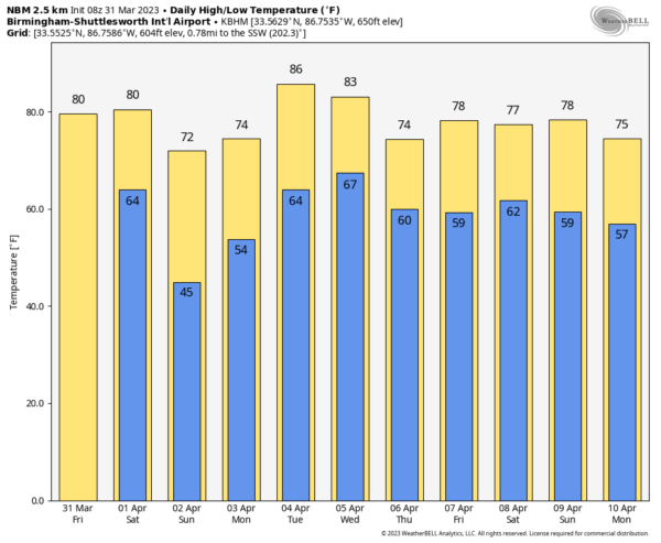
RADAR CHECK: We have some light rain over the northern quarter of Alabama this morning, but much of today will be dry. The sky will be mostly cloudy, and temperatures rise into the 77-81 degree range this afternoon. South winds will increase this afternoon, gusting to 25/30 mph times.
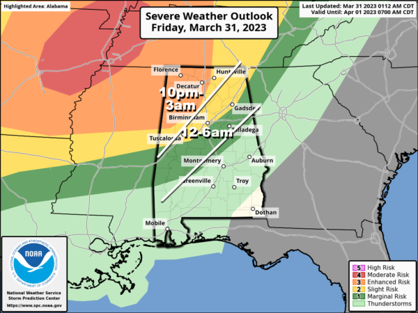
TONIGHT: A dynamic weather system will bring an organized band of showers and thunderstorms into Alabama late tonight. SPC maintains an “enhanced risk” (level 3/5) of severe storms for areas north and west of a line from Madison to Jasper to Reform. A “slight risk” (level 2/5) extends as far south as I-59 (Gadsden, Birmingham, Tuscaloosa)… and a “marginal risk” (level 1/5) is down to Heflin, Clanton, and Thomasville.
Storms will enter Northwest Alabama in the 10:00 p.m. to midnight window… the line of storms will move southeastward after midnight. The core tornado threat is in the “enhanced risk” across Northwest Alabama, and SPC suggests a strong tornado (EF-2 or higher) is possible there. The threats will be mainly damaging straight line winds and hail during the pre-dawn hours as the storms shift southward.
As always, it is very important to be able to hear warnings in the middle of the night as they are issued; the baseline is a NOAA Weather Radio. Be sure “Do Not Disturb” and “Sleep Mode” as disabled on your phone so you won’t miss any notifications.
Gradient winds will average 15-25 mph of the storms, with gusts to 40 mph possible in spots across North Alabama. A wind advisory is in effect for roughly the northern half of the state.
The weakening line of storms will shift into South Alabama tomorrow morning, and should be out of the state by early afternoon. Severe storms are not expected across South Alabama tomorrow. For North/Central Alabama… tomorrow will be a dry day after the lingering early morning showers with a mostly sunny sky and a high between 75 and 80 degrees.
Sunday will be a nice day; with a sunny sky the high will be in the low to mid 70s.
NEXT WEEK: At this point it looks like there will be some risk of rain on a daily basis. Strong storms are possible late Tuesday night into Wednesday as a cold front settles into the state, but it is too early to know if we have a meaningful severe weather threat. The front becomes stationary, meaning showers and storms will remain possible Thursday and Friday. Highs through the week will be in the 70s and 80s. See the video briefing for maps, graphics, and more details.
ON THIS DATE IN 1962: A tornado struck the town of Milton, Florida killing 17 persons and injuring 100 others. It was the worst tornado disaster in Florida history.
ON THIS DATE IN 1973: A devastating long track F3 tornado took a nearly continuous 75-mile path through north-central Georgia causing more than 104 million dollars damage. The tornado first touched down near Jonesboro, GA aroud 5:30 pm and carved an 75 mile long path through Clayton, Henry, Dekalb, Rockdale, Walton, Oconee, Clarke, and Oglethorpe counties before finally dissipating 10 miles ENE of Athens. Two were killed, one near Conyers and a second victim in Athens.
ON THIS DATE IN 2020: A tornado moved through the southern part of Eufaula. The most significant damage occurring in the Country Club of Alabama neighborhood along the south side of Pebble Beach Drive. Large sections of roofs were removed from a few well built residences with collapse of some exterior walls. The tornado crossed the Walter F. George Reservoir along the Chattahoochee River and continued into Quitman County in Georgia.
BEACH FORECAST: Click here to see the AlabamaWx Beach Forecast Center page.
Look for the next video briefing here by 3:00 this afternoon… enjoy the day!
Category: Alabama's Weather, ALL POSTS, Weather Xtreme Videos


