Saturday Weather Briefing — Much Calmer Today; Strong to Severe Storms Possible on Sunday
Sorry, the video is short today, but I am in the middle of severe weather coverage as I make this briefing at the insane hour of 2:15 am Saturday morning. At this point, the line of storms has not made it to the I-59 corridor yet. Here’s what I got for you…
Showers and storms will end early in the day today, and skies will eventually become mostly sunny. Highs will top out in the upper 70s to the mid 80s from northwest to southeast.
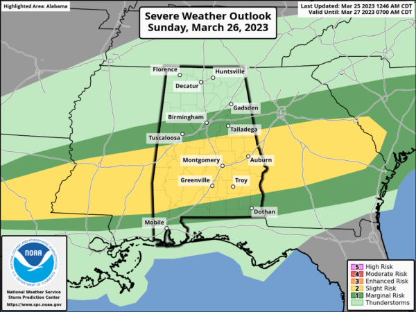
Unfortunately, we are not out of the woods for severe storms this weekend. Rain and storms will be possible over the area, and there is a threat of stronger to severe storms along and south of a line from roughly Millport to Warrior to just south of Gadsden. Threats will be from damaging winds up to 60 mph and hail. This doesn’t look like a tornado setup, so that threat will be very near zero. Timing will be from 12 pm through 8 pm. Highs in the mid 70s to the lower 80s.
Showers and storms will be possible on Monday, as a lingering front will be moving toward the Gulf Coast, especially during the morning and early afternoon. Highs in the mid to upper 70s. Other than a stray shower before noon, Tuesday looks to be dry for much, if not all, of Central Alabama. Highs in the upper 60s to the lower 70s.
Dry weather can be expected on Wednesday and again on Thursday as the next system begins to build out to the west. Highs in the upper 60s to the lower 70s on Wednesday, and in the 70s on Thursday.
And at the end of the forecast period on Friday, that system looks to move in late with rain and storms likely, some of the storms could be on the stronger side. For now, the severe threat only looks to be marginal at this point. Highs in the upper 70s to the mid 80s.
Category: Alabama's Weather, ALL POSTS, Severe Weather, Weather Xtreme Videos


