Alabama Update at 10 p.m.: Storms Getting Close Now
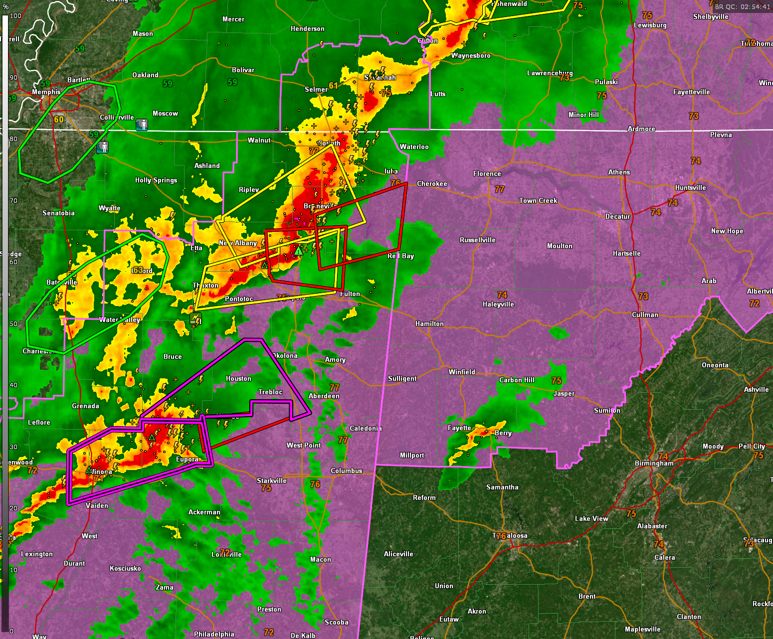
Storms in Northeast Mississippi near Blue Springs have strong indications of potential wind damage and a possible tornado. It also has indications of golfball sized hail
This storm will be moving toward Northwest Alabama’s Franklin, Colbert, and Lauderdale Counties. ETA to the Alabama border is less than one hour before 10:30.
The long-track supercell that has been crossing Mississippi with lots of damage is now west of Bellefontaine and Walthall in Webster County. It still has a PDS warning on it. The rotation is not quite as intense and there is no debris signature currently. The storm is in an environment that it is a little less unstable, but the shear is still extremely high.
These storms may impact Marion and perhaps northern Lamar County up into southern Franklin. Folks in those areas should be preparing in case immediate action is needed soon.
A second tornado is moving into Winona MS. Chasers report that the first tornado may have missed the middle of town. There is damage 2.5-3 miles east of Winona. There is no power in the town.
A new mesoscale discussion was just issued for Northwest Alabama:
THE SEVERE WEATHER THREAT FOR TORNADO WATCH 76, 77 CONTINUES.
SUMMARY…SEVERE THREAT, INCLUDING THE POTENTIAL FOR STRONG
TORNADOES AND DAMAGING WINDS, CONTINUES ACROSS PARTS OF NORTHEASTERN
MS INTO NORTHWESTERN AL.
DISCUSSION…LATEST RADAR DATA FROM GWX DEPICTS A WELL-ORGANIZED
SUPERCELL CLUSTER TRACKING EAST-NORTHEASTWARD ACROSS NORTHEASTERN MS
THIS EVENING. AHEAD OF THIS STORM, LOWER 60S DEWPOINTS ARE SPREADING
NORTHWARD IN RESPONSE TO CONTINUED CYCLOGENESIS TO THE NORTH —
SUPPORTING SURFACE-BASED INFLOW. WITH A STRENGTHENING LOW-LEVEL JET
OVER THE AREA (70+ KT 850-MB WINDS) SAMPLED BY THE GWX VWP,
HODOGRAPHS ARE BECOMING INCREASINGLY FAVORABLE FOR INTENSE
SUPERCELLS (EVEN IF EMBEDDED IN LINE SEGMENTS). GIVEN THE AMPLE
STREAMWSIE VORTICITY AND SURFACE-BASED INFLOW FOR THIS STORM, STRONG
TORNADOES AND DAMAGING WINDS REMAIN POSSIBLE FROM NORTHEASTERN MS
INTO NORTHWESTERN AL.
Category: Alabama's Weather, ALL POSTS, Severe Weather
About the Author (Author Profile)
Bill Murray is the President of The Weather Factory. He is the site's official weather historian and a weekend forecaster. He also anchors the site's severe weather coverage. Bill Murray is the proud holder of National Weather Association Digital Seal #0001 @wxhistorianSubscribe
If you enjoyed this article, subscribe to receive more just like it.


