Tornado Watch Coming for Northwest Alabama
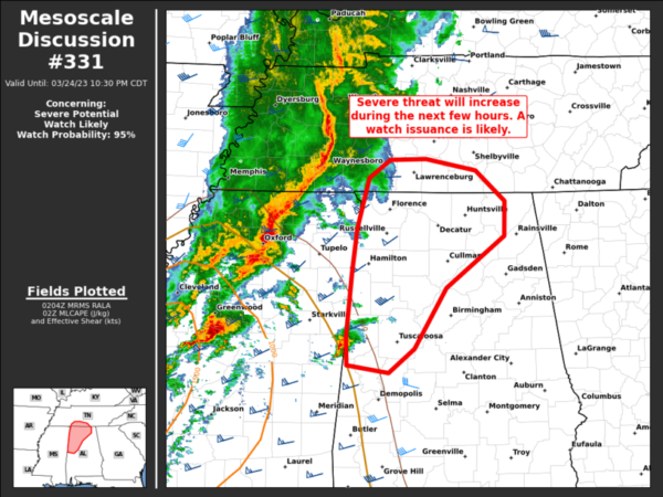
The Storm Prediction Center and NWS Offices are coordinating a new Tornado Watch for the northwestern part of Alabama and southern Middle Tennessee.
Here is the text of the Nesoscale discussion:
Mesoscale Discussion 0331
NWS Storm Prediction Center Norman OK
0907 PM CDT Fri Mar 24 2023
Areas affected…Parts of northwestern AL into Middle TN
Concerning…Severe potential…Watch likely
Valid 250207Z – 250330Z
Probability of Watch Issuance…95 percent
SUMMARY…The risk of severe storms capable of all hazards will
increase over portions of northwestern AL into Middle TN during the
next few hours. A watch issuance is likely before 0230Z.
DISCUSSION…A QLCS is tracking eastward across western TN into
northern MS, while northeastward-moving supercells are ongoing over
northern into central MS. As a large-scale trough evident in water
vapor imagery continues eastward this evening, the warm sector
(characterized by middle/upper 60s dewpoints) will spread eastward
into parts of western AL and Middle TN. At the same time, a
strengthening low-level jet will also shift eastward over the warm
sector, favoring a continuation of the severe storms with eastward
extent. Large/clockwise-turning hodographs (sampled by regional VWP)
will support organized storms including supercells (even if embedded
in a line) with a risk of tornadoes, damaging winds, and large hail.
A watch will likely be issued for parts of this area before 0230Z.
..Weinman/Thompson.. 03/25/2023
Category: Alabama's Weather, ALL POSTS, Severe Weather


