Sunny, Cool Day Ahead; Another Freeze Tonight
COLD MARCH MORNING: Here are some temperatures just before sunrise across Alabama early this morning….
Gadsden 27
Heflin 28
Haleyville 29
Morris 29
Cullman 30
Fort Payne 30
Huntsville 31
Birmingham 31
Hueytown 31
Anniston 32
Jasper 32
Talladega 32
Pell City 32
Muscle Shoals 33
Tuscaloosa 35
Montgomery 41
Mobile 44
These are not the lows for the day… the readings will drop a few more degrees before starting to rise.
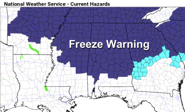
Today will be sunny and cool with a high in the 50s for North Alabama, with 60s to the south. Then, another freeze is likely for the northern 2/3 of the state late tonight and early tomorrow. A freeze warning is in effect as far south as Butler, Grove Hill, Camden, Greenville, Troy, and Eufaula. Temperatures could be a little colder than what we are experiencing this morning with a calm wind expected.
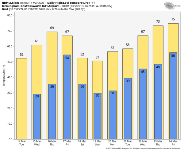
Dry weather continues tomorrow and Thursday with a warming trend. Highs will be in the 60s tomorrow, and in the 68-75 degree range Thursday. Clouds return Thursday night, and Friday promises to be a wet day with occasional rain and possibly a thunderstorm. There will be no surface based instability over most of the state, so no risk of severe storms, with the possible exception of the Gulf Coast. Rain amounts Friday will be around one inch, with locally heavier amounts.
THE ALABAMA WEEKEND: Another shot of cold air rolls into the state Saturday. The sky becomes partly to mostly sunny, with highs ranging from the upper 40s over the northern third of the state to the 60s for South Alabama. Another late season freeze is likely Sunday morning… we project a low in the 22-32 degree range over the northern counties. Sunday will be a sunny, cool day with highs in the 50s and 60s.
NEXT WEEK: Another freeze is likely for North/Central Alabama early Monday, followed by a warming trend. Global models are not in especially good agreement, but it looks like rain will return to much of the state Tuesday, followed by another chance of rain Friday. Temperatures reach the 70s by the end of the week… See the video briefing for maps, graphics, and more details.
ON THIS DATE IN 1933: A deadly tornado outbreak affected the Middle Tennessee region, including Nashville, on this day. The outbreak, which produced five or more tornadoes, killed 44 people and injured at least 461 others. The strongest tornado, F3, cut a path through the center of Nashville. About 1,400 homes were damaged or destroyed. Windows were blown out of the State Capitol Building.
ON THIS DATE IN 2008: The SEC basketball tournament was underway in Atlanta, and Alabama/Mississippi State was going into overtime when a loud roaring sound was heard. Television announcers said that it sounded like a freight train. Lights and catwalks in the Dome began to sway and debris rained down inside the arena. Players on the court stopped and fans in the upper levels of the arena began to panic. No one knew what was going on. There were no public address announcements about the severe weather outside until well after the storm had hit.
The court was cleared and order restored, but outside, the scene was like that of a war zone. Damage was widespread. An F2 tornado had struck downtown Atlanta. The tornado damaged not only the Georgia Dome, Philips Arena, the CNN Center, and the Omni Hotel, but it blew windows out of downtown hotels, cars, and buildings and even caused the collapse of several buildings. In the nearby historic Cabbagetown district, several homes and buildings were destroyed. Over fifty homes were destroyed and the Cotton Mill lofts were heavily damaged.
Tragically, one person was killed in the tornado in a collapsed building. Thirty were injured in the tornado.
BEACH FORECAST: Click here to see the AlabamaWx Beach Forecast Center page.
Look for the next video briefing here by 3:00 this afternoon… enjoy the day!
Category: Alabama's Weather, ALL POSTS, Weather Xtreme Videos


