Freeze Potential Ahead Both Tomorrow And Wednesday Morning
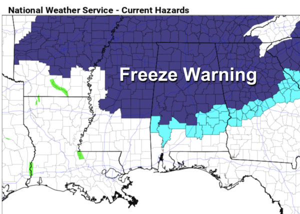
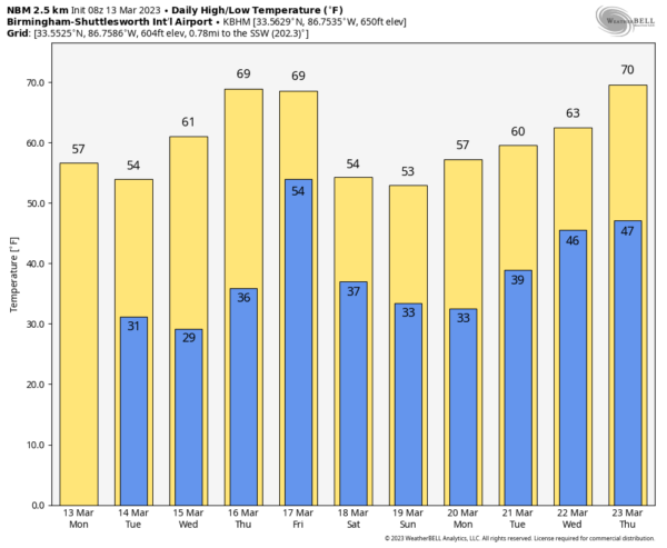
LATE SEASON FREEZE: Drier, colder air is over Alabama this morning… the sky will be partly to mostly sunny today with a high between 55 and 65 degrees. A freeze warning is in effect for much of North and Central Alabama for tonight and tomorrow night as temperatures drop into the 25-35 degree range. The freeze warning extends as far south as Demopolis, Selma, Prattville, Dadeville, and Lafayette.
Tomorrow will be a sunny, cool day with highs in the 50s and 60s, and temperatures early Wednesday will be in the sub-freezing range again for the northern 2/3 of the state (generally ranging from 25-35 degrees). Some frost is possible Wednesday morning down into South Alabama. Then, during the day Wednesday, the sky will be sunny with a high in the 60s.
Temperatures reach the 70s Thursday afternoon with a good supply of sunshine. Clouds return Thursday night, and rain arrives Friday ahead of another cold front. For now, severe storms are not expected over most of Alabama due to the lack of surface based instability, but strong storms are very possible along the Gulf Coast. Rain amounts Friday will be around one inch.
THE ALABAMA WEEKEND: Another shot of colder air arrives Saturday… the sky becomes partly to mostly sunny with highs in the 50s and 60s. Then, another late season freeze seems likely for much of North/Central Alabama by early Sunday morning with lows back in the 25-35 degree range. Sunday will be sunny and cool with highs in the 50s for North Alabama, with 60s for the southern counties of the state.
NEXT WEEK: Freezing temperatures are possible again early Monday morning, followed by a warming trend. A batch of rain and storms will likely arrive by mid-week… See the daily Weather Briefing video for maps, graphics, and more details.
ON THIS DATE 30 YEARS AGO: The generational “Blizzard of 93” was winding down. All 67 Alabama counties had measurable snow; winds gusted to nearly hurricane force on ridges with white out conditions, snow amounts of 1 to 2 feet were common over the northern half of the state, with drifts to 5 feet. There was a lot of eerie green lightning followed by the muffled sound of thunder during the peak of the storm. With the atmosphere overloaded with big snowflakes, part of the sound of thunder was absorbed. Some had no power for over a week.
We forecast 6 to 16 inches of snow going into the event, but many didn’t believe it since we were in mid-March, the flowers were blooming, and the high on March 10, 1993 (two days before the blizzard) was 75.
The storm dropped 13 inches at the Birmingham International Airport, where the records are kept, and almost two feet of snow across parts of southern Jefferson and northern Shelby counties. The heaviest snow across the Southeast U.S. was recorded was at Newfound Gap, where U.S. 441 crosses the Tennessee and North Carolina border, with five feet. The temperature at Birmingham dropped to 2 degrees on Sunday, March 14, 1993 with a clear sky, light wind, and a huge snow cover.
BEACH FORECAST: Click here to see the AlabamaWx Beach Forecast Center page.
Look for my next video briefing here by 3:00 this afternoon… enjoy the day!
Category: Alabama's Weather, ALL POSTS, Weather Xtreme Videos


