Catching You Up at 8:15 a.m.
Low clouds are racing northeastward across Alabama this morning, providing a dramatic backdrop to the impending severe weather outbreak that we expect across the Southeast today. Those ominous, fast-moving clouds as the result of a powerful low-level jet that is transporting warm, moist air efficiently northward and providing a lot of shear for rotating storms.
Let’s catch you up. Over 121,000 people are without power to the west of Alabama, mainly over North Central and Northeast Texas, but over other parts of Texas, Oklahoma, Arkansas, and Louisiana. Unfortunately, Alabama will get into that action later today with the strong gradient winds and very high wind gusts from a line of storms that will cross the state today.
Winds gusted to 87 mph yesterday at Grand Prarie in the Dallas/Ft. Worth Metroplex, 76 in the Highland Park neighborhood. No one was hurt in the Shreveport area, where there was a confirmed tornado.
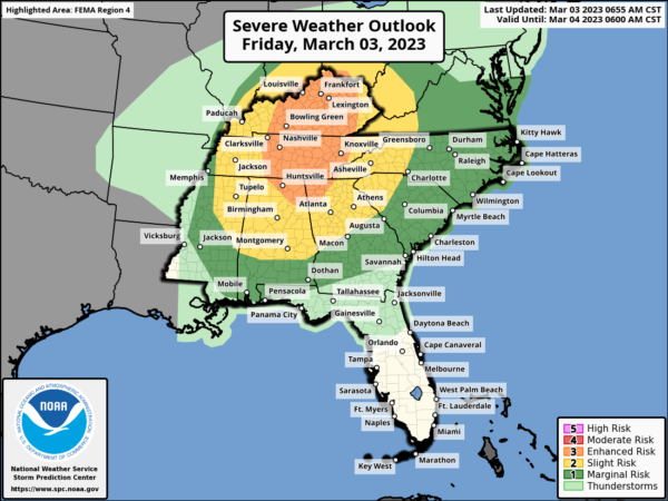
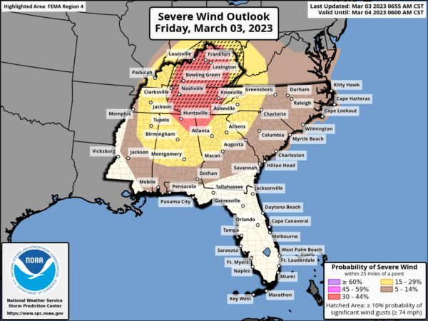
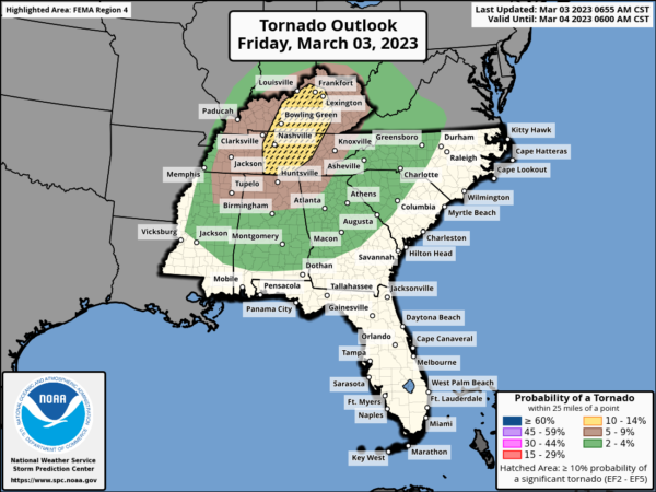
Today’s severe weather threat looks like this.
Damaging winds associated with thunderstorms could reach 60-80, higher than what we normally deal with and much more damaging. And beyond that, winds outside of thunderstorms could just to 60 mph in the rare high wind warning area, which includes North Mississippi, North Alabama, Tennessee, and Kentucky. In the wind advisory area, which includes much of the remainder of the area, winds will gust to 50 mph, outside of thunderstorms. This by itself will down trees and power lines and cause power outages. Those wind alerts are in effect until 9 p.m. tonight.
Of course, today is the 3rd anniversary of the North and East Nashville Tornado and the EF4 that hit Crossville, TN in the middle of the night.
The SPC has upgraded the tornado risk to the north of Alabama. If we get any sunshine during the day, it is not the good thing it seems. It means additional destabilization and an enhanced tornado risk.
Damaging winds are the biggest threat, but any destabilization that can occur with daytime heating will drive significant tornado parameter values off the charts. This potentially higher tornado threat will shift eastward during the morning and into eastern Alabama after lunch over to Atlanta by 4 p.m. or so.
The upper trough is swinging eastward and becoming negatively tilted. You have heard us use that term sometimes in association with a stronger system and higher energy. The low-level jet is helping with both the destabilization process as well as enhancing the wind shear.
Talking about timing, the system has slowed a bit, which could lead to more destabilization while the system is still over Alabama.
A new tornado watch has just been issued for areas from northern Mississippi and Alabama across western Tennessee, western Kentucky, and even into far southeastern Illinois. Another tornado watch will be issued later for counties to the east of the new watch. A local extension of the tornado watch over the Mississippi Delta is being contemplated.
The flood threat is expanding to our north from parts of Arkansas up into western Kentucky. Three are currently 11 flash flood warnings in effect. No severe thunderstorm or tornado warnings for now.
The radar right now is fairly quiet across Alabama with just a few fast-moving showers lighting up the radar. Storms later today could move at 65 to 75 knots, or 75 to 90 mph.
Category: Alabama's Weather, ALL POSTS, Severe Weather


