Very Windy Day Ahead With Severe Thunderstorm Potential
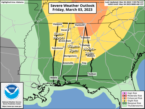
ACTIVE MARCH DAY: A dynamic weather system will bring very windy conditions to Alabama today along with the potential for severe thunderstorms. The system is a bit late in arriving, and the windows for severe storms have been pushed back a few hours. But, the overall forecast concept remains the same.
SPC has now defined an “enhanced risk” (level 3/5) of severe thunderstorms for the northeast corner of the state, from Gadsden and Weiss Lake north to Fort Payne and Scottsboro. A “slight risk” (level 2/5) extends as far south as Camden and Eufaula, and the rest of South Alabama is in a “marginal risk” (level 1/5).
A line of strong to severe thunderstorms will race through Alabama between 8:00 a.m. and 3:00 p.m. The severe threat is somewhat conditional; there is a layer of warmer air aloft acting as a capping inversion, which is a limiting factor. And, shear is so strong that it might prevent sustained updrafts. But, if storms can overcome these factors they will be capable of producing strong, potentially damaging straight line winds and a few tornadoes.
Another big factor today is gradient wind (not related to thunderstorms). Winds will average 15-30 mph, with potential gusts to 50/60 mph in a few spots. A high wind warning is in effect for the Tennessee Valley of North Alabama, and a wind advisory is in effect for the rest of the state. Between the gradient winds and the wind created by thunderstorms today, there is potential for a good bit of tree and power line damage, and accordingly power outages.
We are not expecting big issues with hail or flooding today.
Be sure and pay attention to all warnings today, including severe thunderstorm warnings. Storms will exit the state by 3:00 this afternoon, and winds will diminish this evening.
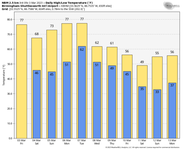
THE ALABAMA WEEKEND: The weekend will feature will pleasant days and clear cool nights. The high Saturday will be in the 65-75 degree range, followed by 70s Sunday. Lows will be mostly in the 40s, but colder pockets across North Alabama could reach the 30s early Sunday morning.
NEXT WEEK: Model consistency is not good concerning weather next week. We will mention a chance of showers during the mid-week period, followed by much colder air by the end of the week and the following weekend (March 11-12). See the daily Weather Briefing video for maps, graphics, and more details.
ON THIS DATE IN 1966: An F5 tornado, which would become known as the “Candlestick Park” tornado, named after a shopping center in south Jackson, was destroyed by the tornado. One of only two documented F5 tornadoes to strike Mississippi in the 20th century. The worst damage occurred in parts of Hinds, Rankin, Scott, and Leake counties, where 57 people were killed and over 500 were injured.
ON THIS DATE IN 2019: A total of 41 tornadoes touched down across Alabama, Florida, Georgia, and South Carolina, with a dozen of them hitting Alabama. A violent EF-4 tornado moved through the Beauregard-Smiths Station communities in Lee County, and was responsible for claiming the lives of 23 people and injuring 90 others. 19 of the 23 people who died were in mobile homes.
BEACH FORECAST: Click here to see the AlabamaWx Beach Forecast Center page.
Look for the next video briefing here by 3:00 this afternoon… enjoy the day!
Category: Alabama's Weather, ALL POSTS, Weather Xtreme Videos


