Severe Storms Possible Tonight Across North Alabama
AT MID-AFTERNOON: We have a mix of sun and clouds across Alabama this afternoon with just a few scattered showers on radar… temperatures are in the 75-83 degree range.
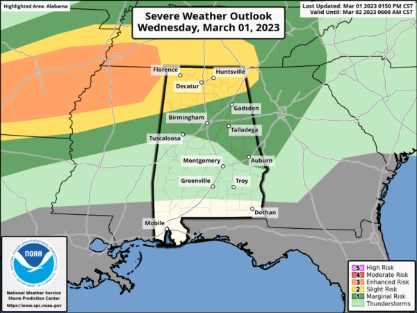
Storms will increase tonight over North Alabama, and SPC has defined a “slight risk” of severe thunderstorms (level 2/5) for ares north of a line from Vernon to Cullman to Sand Rock. A “marginal risk” (level 1/5) extends down to Tuscaloosa, Rockford, and Opelika.
Thunderstorms to the west should congeal into one or more bowing line segments as they spread eastward across the Mid-South and Tennessee Valley this evening and tonight. The greatest concern with storms tonight over North Alabama is from strong winds, although some hail is possible as well.
An isolated tornado can’t be ruled out, but isn’t especially likely (higher tornado probabilities are west of Alabama). Most of the storms tonight will be along and north of U.S. 278 (north of a line from Hamilton to Cullman to Gadsden). Activity to the south will be very isolated.
We also note there is a flash flood watch in effect tonight for the Tennessee Valley of North Alabama.
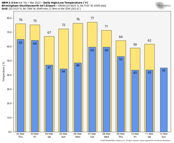
TOMORROW: The day will be mostly cloudy with a decent chance of occasional showers and a few thunderstorms. We aren’t expecting any severe storms tomorrow in Alabama as the main upper support will be well to the west. We note there is a level 4/5 “moderate risk” of severe storms tomorrow afternoon/evening for the ArkLaTex region around Shreveport. The high tomorrow will be in the 75-80 degree range for most places.
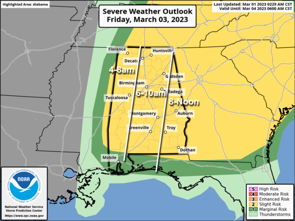
FRIDAY: A fast moving line of showers and storms will move through the state Friday morning; SPC has most of Alabama in a “slight risk” (level 2/5).
Thankfully there will be limited surface based instability available, but kinematics/dynamics will be very strong, and the line of storms will be capable of producing damaging winds. An isolated tornado or two can’t be ruled out as well along the line. Be sure and pay attention to severe thunderstorm warnings Friday morning as they are issued.
We also note that gradient winds (not related to thunderstorms) will be very strong Friday, so expect some power outages. The sky will clear Friday afternoon following the storms with a high in the 65-70 degree range.
THE ALABAMA WEEKEND: Expect sunny pleasant days and fair cool nights over the weekend… the high Saturday will be in the 60s, followed by 70s Sunday. Lows will be mostly in the 40s, but colder spots could visit the upper 30s early Sunday morning.
NEXT WEEK: Monday will be dry and mild… then we will bring in a chance of showers for the northern half of the state Tuesday and Wednesday. For now we aren’t expecting any severe thunderstorms next week; See the daily Weather Briefing video for maps, graphics, and more details.
ON THIS DATE IN 1983: Two tornadoes caused damage in the Los Angeles areas during the morning hours. The strongest tornado was an F2 on the ground for 21 minutes.
ON THIS DATE IN 2007: An EF-4 tornado slammed into Enterprise, in South Alabama. Large sections of the town were severely damaged before the storm with winds of 170 mph hit Enterprise High School during the middle of the school day. Eight students were killed and 50 more were taken to area hospitals. Another local resident died in her home bringing the death toll to nine. A tornado warning was in effect 18 minutes before the storm reached Enterprise.
The school officials did the right thing by keeping the students in school. The death toll, most likely, would have been much higher if those high school kids were out in their cars or in homes hit by the tornado.
The eight students who died that day were Michael Bowen, Peter Dunn, A.J. Jackson, Ryan Mohler, Katie Strunk, Michael Tompkins, Jamie Ann Vidensek, and Michelle Wilson.
BEACH FORECAST: Click here to see the AlabamaWx Beach Forecast Center page.
Look for the next video briefing here by 6:00 a.m. tomorrow…
Category: Alabama's Weather, ALL POSTS, Weather Xtreme Videos


