Severe Storms Likely Across Alabama This Afternoon
ACTIVE DAY AHEAD: A dynamic weather system will bring the risk of strong to severe thunderstorms across Alabama this afternoon and tonight. This event has been advertised for the last seven days by SPC (NOAA’s Storm Prediction Center), so hopefully everyone is prepared in case things rough.
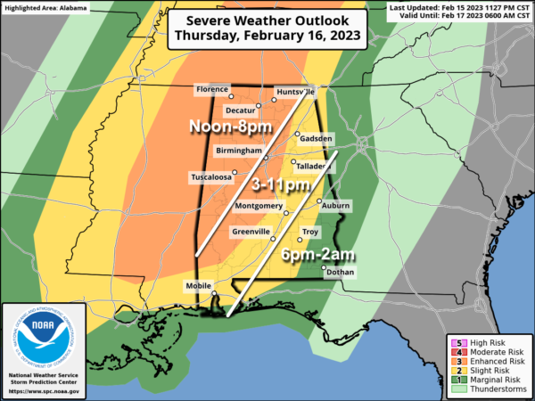
An “enhanced risk” (level 3/5) of severe thunderstorms is in place for areas west of a line from near Scottsboro to Pell City to Selma to Jackson. A “slight risk” (level 2/5) covers much of the rest of the state.
Here are the key messages for todays event….
*The window for strong to severe thunderstorms will open up around 12 noon for the far western of the state, with the risk spreading eastward during the afternoon and evening hours. The event will wind down a little after midnight for southeast Alabama.
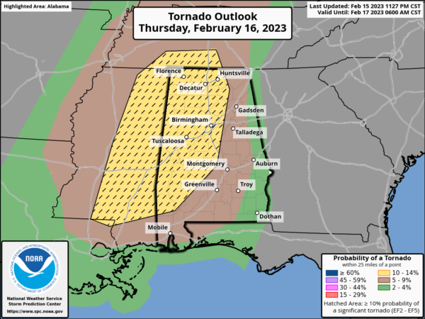
*Thunderstorms across Alabama this afternoon and tonight will be capable of producing large hail, damaging winds, and a few tornadoes. The higher tornado probabilities are across much of West and Central Alabama, where SPC has defined a hatched area, meaning a strong tornado is possible (EF-2 or higher). This area includes places like Muscle Shoals, Huntsville, Cullman, Fayette, Jasper, Birmingham, Tuscaloosa, Demopolis, Selma, and Thomasville.
*Gradient winds this afternoon (not related to thunderstorms) will average 15-25 mph, with gusts at time to 30 mph ahead of the storms.
*Rain amounts will be in the 1 to 2 inch range, with isolated heavier amounts. Some isolated flooding issues are possible.
*Have a reliable way of hearing severe weather warnings (NEVER an outdoor siren). The baseline is a NOAA Weather Radio; every home and business needs one. Have WEA (Wireless Emergency Alerts) enabled your smart phone. Download the free ABC 33/40 Weather app.
*Know the safe place in your home and business… a small room (hall, closet, bathroom) on the lowest floor. Near the center, away from windows. In that safe place have helmets for everyone. Air horns and hard sole shoes as well.
*If you live in a mobile home, you can’t stay there if you are in a tornado warning polygon. Know the nearest shelter or business that can used as a shelter. Have transportation arranged.
*You can be a hero today. If you know of a friend or loved one in a tornado warning polygon, call or text them to be sure they know the danger. You can be a big part of the warning process.
*Events like this are common in Alabama during our tornado season, which runs from November through May. No need to be anxious, just be prepared and we will get through the day together just fine.
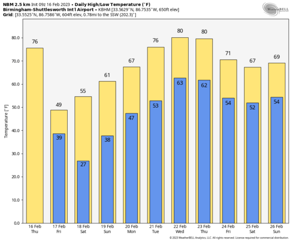
TOMORROW AND THE WEEKEND: Tomorrow will feature a clearing sky as a much colder airmass moves into the state… temperatures will hold in the 40s over the northern third of the state, with 50s to the south. We start the weekend with 20s early Saturday morning, followed by a high in the 50s with a sunny sky. Sunday will be another sunny day with highs in the 60s.
NEXT WEEK: The warming trend continues; we rise into the low to mid 70s Monday and Tuesday, and the latest guidance suggests we will see 80 degree warmth by Wednesday and Thursday, our warmest weather so far this year. Models have not been very consistent on rain chances; for now it looks like a few showers are possible by mid-week, but it doesn’t look especially heavy or widespread. See the daily Weather Briefing video for maps, graphics, and more details.
ON THIS DATE IN 1995: A pre-dawn tornado tore through the communities of Joppa and Arab in Cullman and Marshall counties. The F3 tornado chewed its way across the southern side of Arab, reaching US-231 at 5:08 a.m. One person was killed in Cullman County. Five died in Marshall County. A total of 130 people were injured along the tornado’s 14 mile path. Joppa Elementary School was destroyed.
BEACH FORECAST: Click here to see the AlabamaWx Beach Forecast Center page.
Look for the next video weather briefing here by 3:00 this afternoon (weather allowing)… enjoy the day!
Category: Alabama's Weather, ALL POSTS, Weather Xtreme Videos


