Severe Storms Likely Across Alabama Tomorrow Afternoon/Evening
RADAR CHECK: It is a mostly cloudy and mild February day across Alabama; a few widely scattered shower are on radar at mid-afternoon, but nothing heavy or widespread. Scattered showers remain possible through tonight; the severe weather threat overnight will remain west of Alabama.
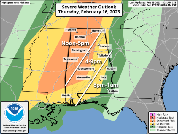
ACTIVE DAY TOMORROW: SPC maintains an “enhanced risk” (level 3/5) of severe thunderstorms for areas west of a line from Scottsboro to Pell City to Selma to Grove Hill. the rest of the state is in a “slight risk” (level 2/5)…
Here are the key messages for tomorrow’s event…
*The window for strong to severe thunderstorms will open up around 12 noon for the northwest corner of the state, with the risk spreading to the southeast during the afternoon and evening hours. The event will wind down a little after midnight for southeast Alabama.
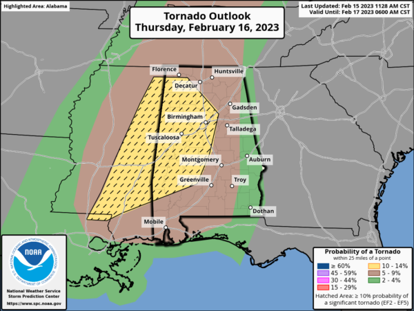
*Thunderstorms across Alabama tomorrow afternoon and evening will be capable of producing large hail, damaging winds, and a few tornadoes. The higher tornado probabilities are across much of West Alabama, where SPC has defined a hatched area, meaning a strong tornado is possible (EF-2 or higher). The hatched area was expanded a bit in the late morning SPC update.
*Gradient winds (not related to thunderstorms) will average 15-25 mph, with gusts at time to 30 mph ahead of the storms.
*Rain amounts tomorrow will be around one inch, with isolated heavier amounts. For now flooding issues are not expected.
*Have a reliable way of hearing severe weather warnings tomorrow (NEVER an outdoor siren). The baseline is a NOAA Weather Radio; every home and business needs one. Have WEA (Wireless Emergency Alerts) enabled your smart phone. Download the free ABC 33/40 Weather app.
*Know the safe place in your home and business… a small room (hall, closet, bathroom) on the lowest floor. Near the center, away from windows. In that safe place have helmets for everyone. Air horns and hard sole shoes as well.
*If you live in a mobile home, you can’t stay there if you are in a tornado warning polygon. Know the nearest shelter or business that can used as a shelter. Have transportation arranged.
*You can be a hero tomorrow. If you know of a friend or loved one in a tornado warning polygon, call or text them to be sure they know the danger.
*Events like this are common in Alabama during our tornado season, which runs from November through May. No need to be anxious, just be prepared and we will get through the day together just fine.
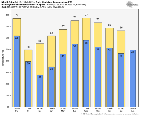
FRIDAY AND THE WEEKEND: Friday will feature a clearing sky as a much colder airmass moves into the state… temperatures will hold in the 40s over the northern third of the state, with 50s to the south. We start the weekend with 20s early Saturday morning, followed by a high in the 50s with a sunny sky. Sunday will be another sunny day with highs in the 60s.
NEXT WEEK: The warming trend continues; we rise into the low to mid 70s during the first half of the week. A few showers are possible by Tuesday, and there will be a some risk of rain statewide Wednesday into Thursday. See the daily Weather Briefing video for maps, graphics, and more details.
ON THIS DATE IN 1564: Galileo Galilei, who invented the telescope, the compass, and the thermometer, was born on February 15th, 1564.
BEACH FORECAST: Click here to see the AlabamaWx Beach Forecast Center page.
Look for the next video weather briefing here by 6:00 a.m. tomorrow…
Category: Alabama's Weather, ALL POSTS, Weather Xtreme Videos


