It’s Gray, Dreary, & Rainy at Midday
As we have hit the noon hour, much of Central Alabama, especially the eastern half of the area, is covered over with light to moderate rainfall. Where it is not currently raining, skies are cloudy and temperatures remain cool. All of this activity will continue to push north-northeastward through the remainder of the day. Temperatures as of the noon roundup were in the mid 40s to the lower 50s, and afternoon highs are only expected to top out in the lower to mid 50s.
For tonight, rain will continue to be likely and there may even be a couple of claps of thunder over the northeastern parts of Central Alabama. For now, I don’t see a mix of snow occurring before sunrise. Overnight lows in the mid 30s to the lower 40s.
Rain will be in the process of moving out of the area early on Sunday, and we may see a brief mix of rain and snow over the far north and northeastern parts of the area before it exits. However, temperatures will be well above freezing and no travel issues are expected. Skies will become partly sunny before sunset and highs will reach the upper 40s to the upper 50s.
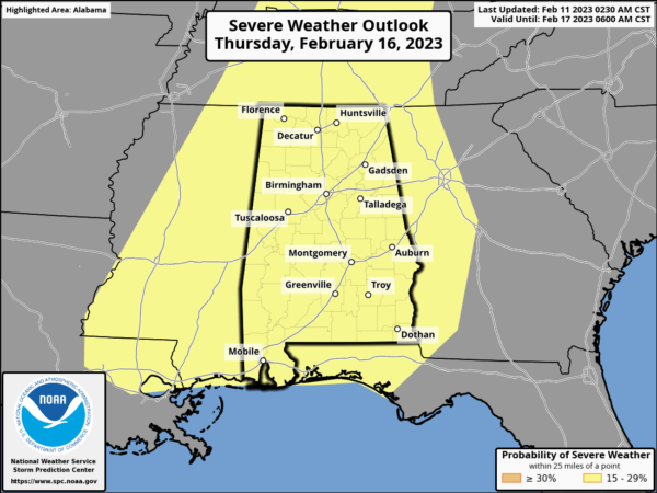
We will have to keep our eyes on the upcoming severe weather threat on Thursday. As of now, all of Alabama is under a Slight Risk of severe weather from the SPC, which is a rarity on a day six outlook. All modes of severe weather look possible at the moment. Now is a great time to get prepared and have those plans ready to go. It is also a great time to go over our Severe Weather Awareness Week posts from this week to help you in remembering what to do and when to act if your location goes under a watch or warning.
Category: Alabama's Weather, ALL POSTS, Severe Weather


