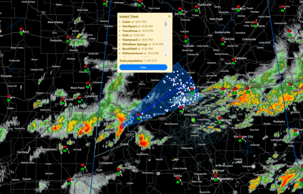
Timing on the West Alabama Severe Storms; Flash Flood Threat Increasing; Flash Flood Watch Extended Northward
The severe warned storm along the Pickens/Greene County line will affect the following areas at the following times:
Coker/Buhl 8:38
Tuscaloosa/Northport 8:48-8:56
Windham Springs 9:15
Rock Creek 9:48
Hueytown/Parrish 9:51
Pleasant Grove 9:58
Adamsville/Graysville 10:05-10:09
Other parts of the Birmingham area by 10:15
This is based on current motion of 35 mph. If the storm speeds up, it could be sooner to your location.
Other strong storms are lined up back to the west across East Central Mississippi back to Macon, Louisville, and Kosciusko.
Others are back along I-55 west of Jackson and north of Canton.
Some sub-severe storms are lifting through the Birmingham Metro area right now with heavy rain.
All of this will have to move through Alabama later tonight ahead of a cold front. This is why you will want to have a reliable means of hearing warnings overnight. Once that will wake you up.
A new severe weather watch will be issued soon for parts of Alabama. There is some debate about whether it will be a tornado watch or a severe thunderstorm watch. The thinking is that the tornado threat may increase a little over the next few hours as surface winds back to the southeast a little more.
The threat for flooding in of increasing concern tonight. The NWS in Birmingham has added a couple of rows of counties above the existing flash flood watch. New counties include: Tuscaloosa-Jefferson-Shelby-Talladega-Clay-Randolph-Sumter-Greene-Hale-Bibb. This includes the cities of Alabaster, Hoover, Moundville, Tuscaloosa,
Birmingham, Roanoke, Pelham, Livingston, Talladega, Ashland, Eutaw, Sylacauga, Greensboro, Centreville, and Columbiana.
Category: ALL POSTS


