Afternoon Weather Briefing — Winter Weather Advisory Issued for the Tennessee Valley
*** No afternoon video. Holiday schedule for this week. ***
Some wintry precipitation continues to fall over the northern-third of Alabama this afternoon, and we are starting to get some reports in about slick spots. Here is the latest update from NWS Huntsville:
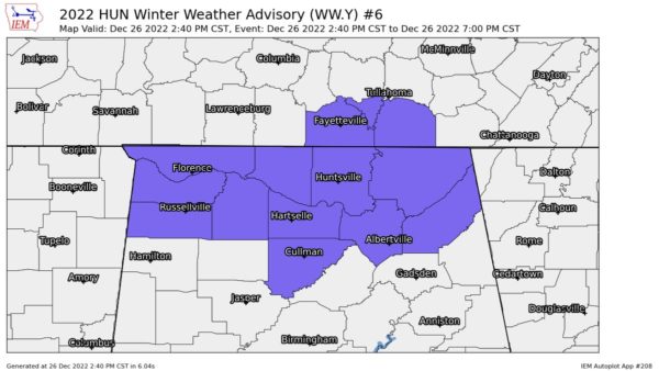
Partners, we’re getting quite a few more reports of slick roads here. NWS Huntsville has issued a Winter Weather Advisory to highlight the hazardous travel conditions through 7 PM. Snow totals won’t be that impressive…but slick roads, especially on a busy travel day are the biggest concern.
Getting reports of slick bridges on Hwy 72 and I-565…secondary roads will likely also be an issue shortly, especially underneath the heaviest bands.
A Winter Weather Advisory has been issued for all the Tennessee Valley counties (Colbert, Cullman, DeKalb, Franklin, Jackson, Lauderdale, Lawrence, Limestone, Madison, Marshall, and Morgan) from now until 7 pm tonight. Plan on slippery road conditions, especially bridges and overpasses. The hazardous conditions could impact the evening commute. Slow down and use caution while traveling.
A couple of Special Weather Statements have been issued for several counties in the northern parts of Central Alabama as well for the snow flurries or light snow showers that are currently falling or will soon to be falling. Temperatures will hover near or drop to the freezing mark by around 4 pm. Precipitation will be intermittent, and any accumulations are expected to range from just a trace up to a light dusting in a few locations. Although widespread accumulations or travel problems are not anticipated, use caution when traveling on bridges, overpasses, and secondary roadways since a dusting of snow on untreated surfaces may result in slick spots. Those counties include: Marion, Winston, Blount, Etowah, and Cherokee.
For the rest of the afternoon and through the evening, we’ll keep the wintry precipitation in the forecast for the northern counties of the area, while some sprinkles or light rain showers will be possible along and just south of I-20 and I-20/59. No major travel issues are expected, but a few slick spots may occur. Overnight lows, while I know it is still very cold, will only dip into the lower to mid 20s for most. Still, much better than the lower teens and single digits.
TOMORROW: Sunshine returns to Central Alabama as ridging starts to take a hold of our weather pattern. We’ll still have to put up with a few clouds, but the good news is that we’ll be on a warming trend. Afternoon highs will be in the mid 40s to the lower 50s from northwest to southeast.
REST OF THE WEEK: You will see big jumps in the afternoon highs on Wednesday and Thursday. With mostly sunny skies, Wednesday’s highs will be in the mid 50s to the lower 60s, and up in the lower 60s to just below 70 degrees on Thursday. A system will sweep into the area on Friday that will bring showers and a clap of thunder or two into Central Alabama by the early afternoon hours. Highs in the 60s.
THE NEW YEAR’S WEEKEND: The wet weather will continue through the day on Saturday (New Year’s Eve) as the front will finally make through the area just after the fireworks go off at midnight. Showers and thunderstorms will be likely through the day, with the rain heavy at times. There will be some instability present, so a few strong storms over the southern half of the area look to be possible. Highs in the mid 60s to the lower 70s.
Rain will move out of the area before sunrise, and the rest of your New Year’s Day will be dry and mild with clouds beginning to exit Central Alabama. Skies will be mostly sunny with highs in the mid 60s to the lower 70s. Enjoy it while you can as the first full week of January 2023 looks to be wet at times.
Category: Alabama's Weather, ALL POSTS, Winter Weather


