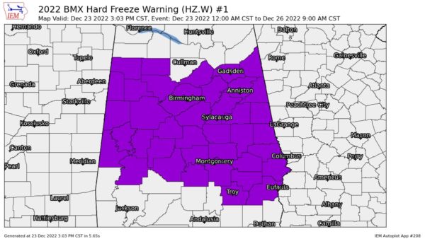
Hard Freeze Warning Extended in Time Until 9 am Monday Morning
NWS Birmingham has extended the HARD FREEZE WARNING originally set to expire at 9 am on Sunday Morning to now expire on Monday morning at 9 am CST for the following counties in Central Alabama: Autauga, Barbour, Bibb, Blount, Bullock, Calhoun, Chambers, Cherokee, Chilton, Clay, Cleburne, Coosa, Dallas, Elmore, Etowah, Fayette, Greene, Hale, Jefferson, Lamar, Lee, Lowndes, Macon, Marengo, Marion, Montgomery, Perry, Pickens, Pike, Randolph, Russell, Shelby, St. Clair, Sumter, Talladega, Tallapoosa, Tuscaloosa, Walker, and Winston.
Sub-freezing temperatures as low as 4º to 12º across Central Alabama Friday night and 10º to 17º across the area Saturday night. A final night of hard freeze conditions is expected Sunday night into Monday morning, with temperatures from 15º to 20º across the area. Southern portions of Central Alabama will rise above freezing during the day Sunday. Far northern portions of Central Alabama may remain below freezing until Monday.
Potential impacts from a prolonged period of subfreezing temperatures may cause pipes to burst. Bitterly cold temperatures and wind chills will result in hypothermia or frostbite and become life-threatening to those with prolonged exposure or without access to adequate warmth. Take steps now to protect tender plants from the cold. To prevent freezing and possible bursting of outdoor water pipes they should be wrapped, drained, or allowed to drip slowly. Those that have in-ground sprinkler systems should drain them and cover above-ground pipes to protect them from freezing.
Category: Alabama's Weather, ALL POSTS, Winter Weather


