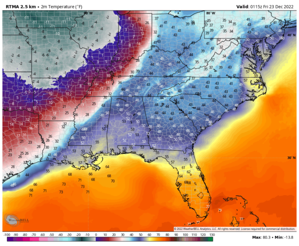
Tracking the Front
We are closely watching surface observations and reports as one of the most impressive Arctic fronts we have seen come towards Alabama in quite some time approaches the state.
The powerful front now extends from just west of Nashville to near Iuka MS to near Tupelo to west of Eupora to Durant to Vicksburg.
A couple of cross sections:
…in Nashville it is 48F while in Dickson, some 40 miles to the west, it is 33F. The wind at Dickson is gusting to 37 mph giving a wind chill of 22. It Dyersburg, it is 14F with light snow and a wind chill of -2F.
…in Muscle Shoals, it is 49F while in Corinth MS it is 32F. In Memphis, it is 15F with blowing snow and wind gusting to 35 mph.
At Batesville MS, the temperature fell from 45F to 23F in less than one hour and 20 minutes. At Greenwood MS, the temperature fell from 48F to 37F in ten minutes.
Further back in the cold air, it is 14F at Little Rock, 4F at Mena AR, and 5F at Oklahoma City.
Light to moderate rain now covers much of western and northwestern Alabama ahead of the front. There is a bit of a break behind the rain area and ahead of the main front, but a line of heavy showers is right along the leading edge of the frontal boundary. A brief changeover to light snow is being observed over North Central Mississippi, with heavier more widespread snow over extreme northern Mississippi and western Tennessee.
Very concerned about flash freezing of any moisture on roads tonight. The temperatures should reach freezing by 9:30 in the Shoals, 11 p.m. in Huntsville and Cullman, Tuscaloosa-Birmingham-Gadsden by 11L30 p.m., and Montgomery/Auburn by 3:30-4 a.m. Remember that bridges can freeze a little sooner.
The NWS in Birmingham also warning that there could be some lake-effect snowfall during the morning hours as extremely cold air crosses the reservoirs along the Tennessee River. This could even affect areas down into Etowah and Cherokee Counties if a persistent fetch sets up over the lakes.
Category: Alabama's Weather, ALL POSTS


