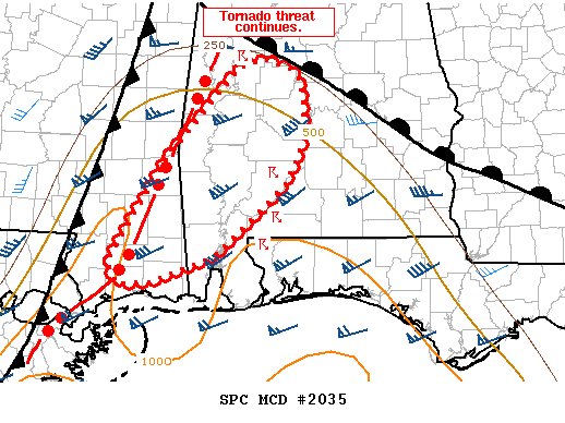
Latest Mesoscale Discussion — Tornado Threat Continues for Locations Under the Tornado Watch
SUMMARY… Several supercell thunderstorms will continue northeastward into this evening with a risk for damaging gusts and a few tornadoes. Certainty in the severe risk decreases with northern and eastern extent.
DISCUSSION… As of 2255 UTC, regional radar and surface analysis showed several supercell thunderstorms ongoing across portions of southeastern MS and southwestern AL. Located primarily along a prefrontal confluence band, these storms are expected to expand northeastward into southwestern and south-central AL over the next couple of hours. While buoyancy decreases with northward extent within moderate stratiform precipitation, sufficient instability likely exists to support strong updrafts into south-central AL. Near the warm front, strong low-level shear (ESRH 400-500 m2/s2) evident on the BMX VAD/VWP will also continue to support strong low-level mesocyclones. Increasingly linear storm modes and interactions do suggest the severe threat is less certain with northern and eastern extent, but the risk for strong wind gusts and tornadoes will likely remain with the more sustained supercells.
New and more shallow convection has also been noted within the free warm sector over southern AL in the last couple of hours. Weak rotation has been observed suggesting additional warm-sector supercell development is possible over the next few hours. Similarly, strong low-level shear would support a tornado risk should these updrafts become more sustained. However, increasing storm interactions cast uncertainty on the severe threat as is depicted on the most recent HRRR runs. Regardless, strong low-level wind fields and adequate CAPE (~1000 J/kg) should support a risk for a few tornadoes should sustained supercells develop.
Category: Alabama's Weather, ALL POSTS, Severe Weather


