Threat for Strong, Long-Track Tornadoes Exists for Southwestern Alabama
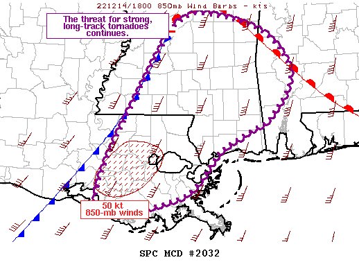
SUMMARY… The threat for strong, long-track tornadoes continues.
DISCUSSION… Regional radar imagery continues to show numerous discrete supercells, including a few which have rotational velocity around 40 to 50 kt. The overall environment remains very conducive to tornadic supercells with ample low-level moisture and buoyancy in the presence of strong low to mid-level flow. Recent KLIX VAD data shows increasing winds in the 1-2 km layer. This increase is likely due to a mesoscale low-level jet, which is expected to move northeastward across far southern MS and into southwest AL over the next several hours. Attendant strengthening of the low-level shear within this corridor could augment the already favorable conditions. Surface observations also numerous gusts of 25 to 30 kt across southeast LA.
Additionally, ongoing storms will likely strengthen as they approach and interact the warm front, which now extends from about 50 miles northwest of MEI southeastward to south of GZH in southern AL.
In all, the threat for strong, long-track tornadoes will continue for at least the next few hours across eastern LA and southern MS, eventually reaching southwest AL later this afternoon/early this evening.
Category: Alabama's Weather, ALL POSTS, Severe Weather


