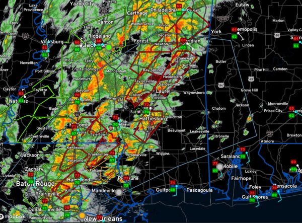
“Trying to Keep Up Folks”…
There are now 10 tornado watrning polygons over Southeast Mississippi and Southeast Louisiana.
Chad Entremont at the National Weather Service Jackson just commented, “Trying to keep up folks…”.
And he has a lot to keep up with as the map above shows. All of the red polygons are tornado warnings.
An earlier report indicated “severe damage” in St. Tammany Parish along Lee Road north of Covington, but this turned out to be false. A tornado was reported to have hit Donaldsonville in Ascension Parish on the Mississippi between Baton Rouge and New Orleans.
Stormchaser Brett Adair reports that the storm coming into Collins MS, west of Laurel, has constant CG lightning strikes associated with it.
These are the storms that are moving into southern Mississippi and eventually Southwest Alabama.
Instability values ramp up quickly behind a warm front that extends from near Meridian to Grove Hill to Brewton over Southwest Alabama. This warm front is lifting northeast. Storms will intensify as they approach this warm front and will gradually weaken after crossing it.
And don’t forget the heavy rain. Flash flood watches are in effect for roughly the northern half of Alabama. The flash flood threat will ramp up quickly in coming hours and flooding could be severe.
Category: Alabama's Weather, ALL POSTS, Severe Weather


