A PDS Tornado Watch Until 8 pm
This is a “Particularly Dangerous Situation” Tornado Watch. Those are pretty rare and are issued when the NWS forecasters have high confidence that multiple strong (F2-F3 on the Fujita Scale) or violent tornadoes (F4-F5 on the Fujita Scale) will occur in the watch area.
That is the case today…
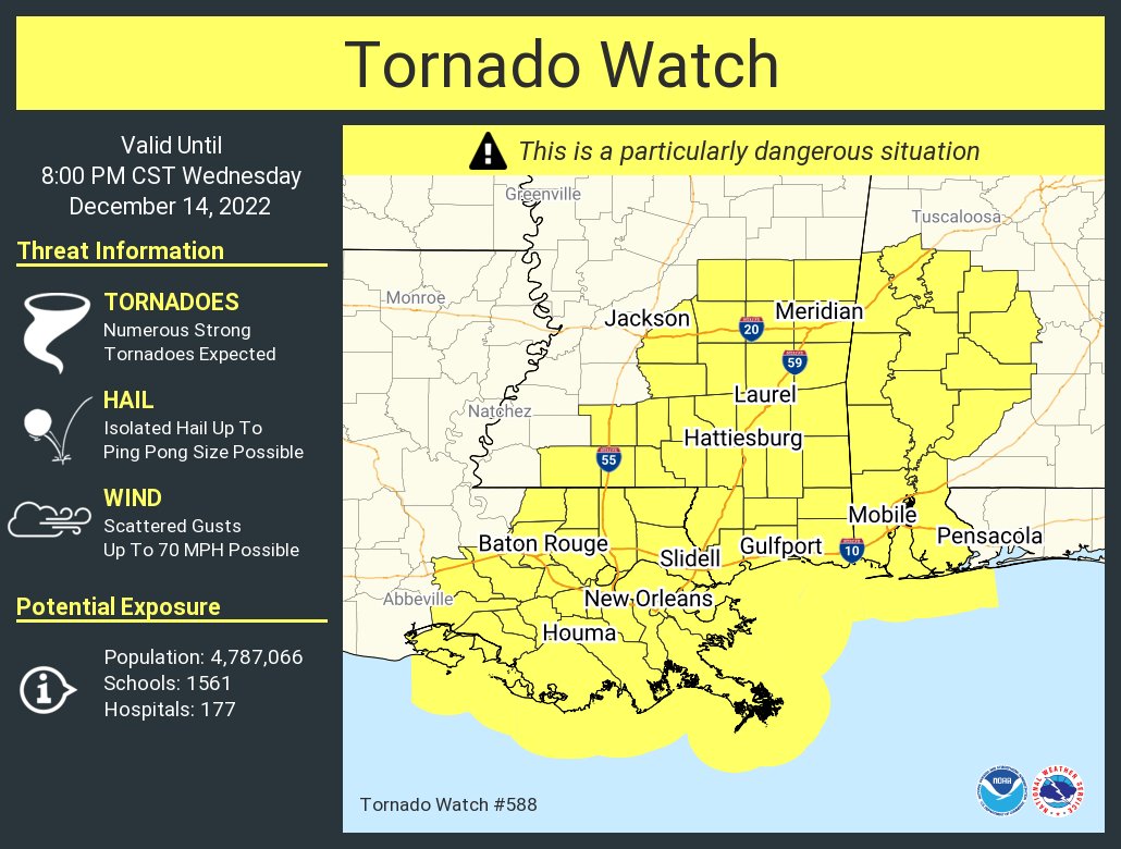
Central Alabama counties include: Dallas, Greene, Hale, Marengo, Perry, and Sumter.
Tornadoes (some strong) and damaging thunderstorm wind gusts are expected later today and this evening for area south of a line from. The threat area is mainly south of a line from Millport to Warrior to Munford, but the highest risk is a little further southwest, from Aliceville to Marion to Selma to Hayneville.
AS John DeBlock as the NWS Birmingham just pointed out though: “Just a reminder. Folks IN AND NEAR the watch areas need to be paying attention. The risk outside of the watches doesn’t magically drop to 0. Severe weather can and does occasionally happen outside of a watched or warned area. If you’re just outside the watch or warning area, you need to say, “hey, I’m just outside this area, and I better pay attention!”.”
We are watching all of the storms to our southwest. Especially the one with the confirmed tornado west of Meridian.
Timing across Central Alabama will be 2-7 p.m. in West Central sections, 4-9 p.m. in the I-65 middle of the state area, and 8 p.m. until 1 a.m. over East Central Alabama.
Category: ALL POSTS
About the Author (Author Profile)
Bill Murray is the President of The Weather Factory. He is the site's official weather historian and a weekend forecaster. He also anchors the site's severe weather coverage. Bill Murray is the proud holder of National Weather Association Digital Seal #0001 @wxhistorianSubscribe
If you enjoyed this article, subscribe to receive more just like it.


