Risk of Supercells Capable of All Severe Hazards Continues Across Tornado Watch Locations
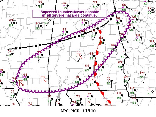
SUMMARY… The threat for supercell thunderstorms capable of all severe hazards continues from southeast MS across southern and central AL.
DISCUSSION… Recent radar imagery continues to show a line of thunderstorms and associated outflow from northeast AL southwestward into central MS. Northern portion of this line over northeast AL has more organization and forward progression over the last hour so, taking it into the more stable air north and east of the warm front. This warm front extends from near SCD southward through south-central AL and into the central FL Panhandle, and is close to the 65 deg F isodrosotherm.
Environment with warm sector west of the warm front and south of the southeastward-progressing outflow will continue to support severe thunderstorms. The storm mode has transitioned to more storm-in-cluster versus truly discrete and the winds have veered throughout the low levels. These factors may impede tornado development, but ample low-level moisture and strong deep-layer vertical shear remain in place. As such, the threat for supercell thunderstorms capable of all severe hazards continues, particularly from east of PIB in southern MS eastward across southern AL.
Category: Alabama's Weather, ALL POSTS, Severe Weather


