Warming Trend Ahead; Rain Returns Later This Week
ANOTHER FRIGID MORNING: Here are some temperatures across Alabama early this morning just before sunrise…
Tuckers Chapel 17
Meridianville 18
Gadsden 18
Oneonta 18
Trussville 19
Haleyville 20
Decatur 20
Cottondale 20
Pell City 20
Chelsea 21
Cullman 21
Jasper 21
Muscle Shoals 22
Talladega 22
Fort Payne 22
Heflin 22
Leeds 23
Huntsville 24
Birmingham 26
Tuscaloosa 26
Demopolis 26
Montgomery 27
Anniston 29
Greenville 29
Dothan 32
Mobile 35
For most of Alabama, this is the fifth consecutive morning with sub-freezing temperatures. Expect a partly sunny sky today with a high in the 50s.
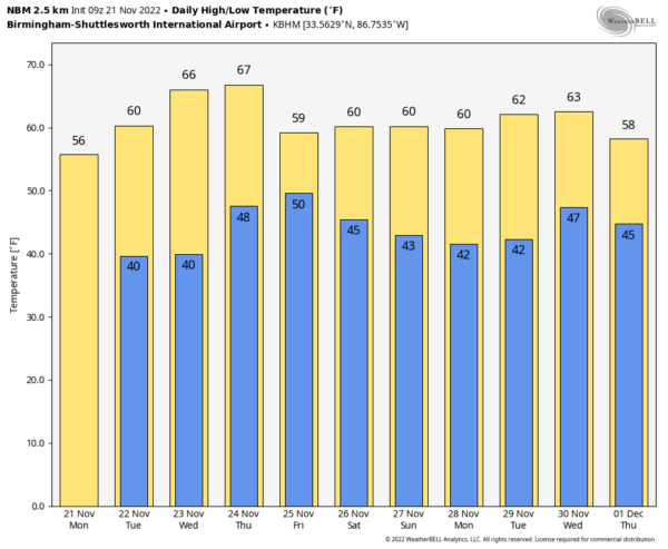
Clouds will increase tonight, and many places will stay above freezing overnight. A disturbance could squeeze out a shower or two tomorrow, but odds of any one spot getting wet are only 10-20 percent. The high tomorrow will be in the upper 50s.
REST OF THE WEEK: Wednesday will be dry and warmer… the sky will be partly sunny with a high in the 60s. Clouds return for Thanksgiving Day, and we will mention a chance of rain at times late Thursday, Thursday night, and early Friday morning. For now it looks like the main window for rain will come from about 3:00 p.m. Thursday through 6:00 a.m. Friday. Rain amounts of around 1/2 inch are likely, and while a rumble of thunder is possible, no severe storms are expected. Temperatures will be very pleasant Thanksgiving Day with a high in the mid to upper 60s. Friday will be a little cooler… with lingering clouds the high will in the 57-62 degree range.
THE ALABAMA WEEKEND: We believe the weekend will be dry with partly to mostly sunny days and fair nights; highs around 60, lows in the 40s.
IRON BOWL: For the biggest football game of the year in Tuscaloosa (Auburn at Alabama… 2:30p CT kickoff), the sky will be partly sunny with a kickoff temperature near 62 degrees, falling back into the 50s by the fourth quarter. For now we see no risk of rain.
NEXT WEEK: The first half of the week looks dry and pleasant with highs in the 60s… global models suggest some risk of rain toward the end of the week. See the daily Weather Briefing video for maps, graphics, and more details.
TROPICS: The Atlantic basin remains quiet, and hurricane season ends in 9 days.
ON THIS DATE IN 1992: The November 21-23, 1992 tornado outbreak was the 3rd largest outbreak in recorded history and one of the longest continuous outbreaks ever recorded. There was no break in tornado activity from 1:30 pm on the 21st when the tornadoes started in Texas until 7:30 am on the 23rd when the last tornadoes lifted in North Carolina. On this date, severe thunderstorms spawned six tornadoes within 70 minutes in the Houston metro area in Texas. At one time, there were three on the ground in Harris County. The strongest, an F4, tracked 20 miles through the eastern suburbs of Houston destroying 200 homes and damaging 1,000 more. Alabama would experience
A long-track F4 had a damage path in Mississippi of 128 miles, stretching from just outside of Hopewell to just west of Sherwood. A total of twelve people were killed, which eight of those were in mobile homes. Another 122 people were injured as this monster tore across seven counties while damaging or destroying at least 700 homes, including well-built brick mansions.
A total of 13 tornadoes would touch down in Alabama on November 22.
BEACH FORECAST: Click here to see the AlabamaWx Beach Forecast Center page.
Look for the next Weather Xtreme video here by 3:00 this afternoon… enjoy the day!
Category: Alabama's Weather, ALL POSTS, Weather Xtreme Videos


