Generally Dry/Mild Weather For Alabama Through Friday
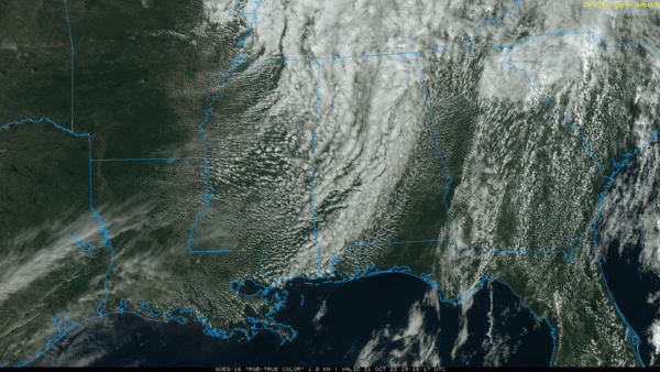
RADAR CHECK: Clouds linger over much of Alabama this afternoon, but so far we aren’t seeing any showers through mid-afternoon. A couple of brief, isolated showers could pop up through the evening hours over the northern third of the state, but odds of any one place seeing rain are less than 15 percent. Looks like a pretty good evening for the trick or treat crowd. Temperatures are in the 67-74 degree range.
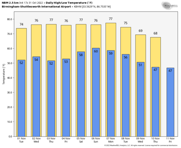
The weather looks mild and mostly dry through the rest of the week. The sky will be partly sunny tomorrow and Wednesday, and while we can’t rule an isolated shower tomorrow night or Wednesday with an approaching upper trough, it looks like the low levels will be too dry for anything meaningful. Thursday and Friday will feature a good supply of sunshine both days; highs through the week will be in the mid to upper 70s for most places, which is above average for early November in Alabama.
THE ALABAMA WEEKEND: Saturday looks dry with a mix of sun and clouds… the high will be in the 76-80 degree range. Then, on Sunday, a few showers are possible mainly over the western and northern counties ahead of a surface front, but with an upper ridge overhead the main dynamic support will be shunted far to the north. Rain amounts should be light and spotty; the high Sunday will be in the upper 70s.
NEXT WEEK: While a few widely scattered showers are possible early in the week, we really don’t see any big rain event through the week as the upper ridge will keep the big rain producers well to the west and north. Temperatures will stay mild with highs well in the 70s… See the daily Weather Briefing video for maps, graphics, and more details.
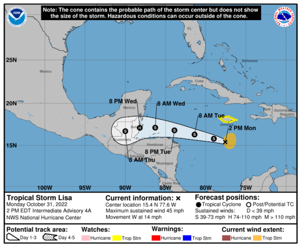
TROPICS: Tropical Storm Lisa has formed in the Caribbean with winds of 45 mph. It will move into Central America around the coast of Belize Wednesday night, most likely as a category one hurricane. Lisa will have on impact on the Gulf of Mexico or the U.S.
Elsewhere, a weak disturbance is northeast of Bermuda in the Atlantic, but NHC gives it only a 10 percent chance of development over the next five days. The rest of the Atlantic basin is very quiet; hurricane season ends in one month.
ON THIS DATE IN 1991: A severe winter storm, dubbed the Great Halloween Mega Storm, struck the upper Midwest. Minnesota bore the brunt of this storm. Blizzard conditions occurred with winds gusting frequently to 40 and 50 mph. By the time it was all over on November 2nd, Duluth recorded 37 inches, Minneapolis 28 inches, International Falls 18 inches and 11.2 inches in 24-hours at Sioux Falls, SD, their earliest heavy snowfall of 6 inches or more and snowiest October on record.
BEACH FORECAST: Click here to see the AlabamaWx Beach Forecast Center page.
Look for the next Weather Briefing video here by 6:00 a.m. tomorrow…
Category: Alabama's Weather, ALL POSTS, Weather Xtreme Videos


