Sunday Weather Briefing: Much Colder Air Ahead
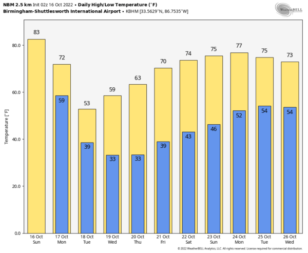
THE WEEK AHEAD: Our coldest air of the season so far will arrive Monday. The first day of the new work week will feature a partly sunny sky with a high in the low 70s, but on Tuesday expect a high in the 54-59 degree range with a very cool north breeze. Temperatures will drop into the 25-35 degree range by early Wednesday and Thursday morning over the northern 2/3 of the state; for many places, it will be the first freeze of the season. Frost will be widespread, even down into parts of South Alabama. Temperatures begin to warm up late in the week with highs back in the low 70s, by Friday, and the week will be rain-free.
EARLIEST FREEZE: This is no insignificant cold snap. Birmingham’s earliest freeze is October 18th, occurring in 1948. With a forecast low of 37F on Tuesday morning and 31F on Wednesday morning, the record may well stay intact. But it will be a pretty close call.
WEEKEND OUTLOOK: The weekend is looking beautiful, with highs warming into the 70s and lows in the 40s.
TROPICS: Tropical Storm Karl dissipated yesterday. THE GFS does develop a tropical system over the Central Atlantic around the 22nd or so, but if it does develop it will remain over open water.
BEACHCAST: A gorgeous day today along the beautiful beaches of Alabama and Northwest Florida. Highs in the 80s, glorious sunshine, can’t beat it. Our frontal system will make it to the beach tomorrow, giving them a chance of showers, although, temperatures will still be warm. Clear and cooler will be the story for the remainder of the week down south, with highs in the 60s Tuesday and Wednesday. Lows will be in the 50s Tuesday morning and 40s Thursday morning! Highs will edge back into the 70s with still fine conditions through the weekend. Water temperatures are in the mid 70s. There is a low rip current risk.
Click here to see the Beach Forecast Center page.
DANCING WITH THE STATS: Madison WI recorded a trace of snow on Thursday. It was the first time they had recorded any snow on 10/13. Another interesting record was from Alma, GA> They recorded no dense fog in September. Only one other year since their records began saw no dense fog in September. That occurred in 1999. Interestingly, they recorded their 5th lowest September dew point ever as they were on the dry left side of Ian tracking to the northon 9/28 and 9/29.
ADVERTISE WITH US: Deliver your message to a highly engaged audience by advertising on the AlabamaWX.com website. The site enjoyed over 29 MILLION page views in the past 12 months. Don’t miss out! We can customize a creative, flexible, and affordable package that will suit your organization’s needs. Contact me, Bill Murray, at (205) 687-0782 and let’s talk.
WEATHERBRAINS: The current show is an outstanding one, with Allyson Rae from NBC-2 in Fort Myers talking all about Hurricane Ian and its impact on her market. Check out the show at www.WeatherBrains.com. You can also subscribe on iTunes. It’s now easier than ever to watch the show live at . You will be able to see the show on the James Spann 24×7 weather channel on cable or directly over the air on the dot 2 feed.
ON THIS DATE IN 1954L The remnants of Hurricane Hazel merged with a cold frontal system, re-energeizing the system and bringing wind gusts to 110 mph and nearly 8.5 inches of rain to Toronto. The heavy rainfall caused extensive flooding and sent the Humber River out of its banks. Eighty people died in Canada. Follow my weather history tweets on Twitter. I am @wxhistorian at Twitter.com.
Category: Alabama's Weather, ALL POSTS, Weather Xtreme Videos


