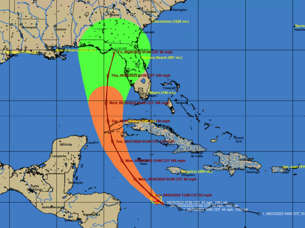
7 a.m. Update on Ian: Ian will be Major Hurricane Over Eastern Gulf of Mexico
Ian is slowly getting organized over the northwestern Caribbean some 250 miles southwest of Kingston, Jamaica.
SUMMARY OF 800 AM EDT…1200 UTC…INFORMATION
———————————————-
LOCATION…15.0N 79.4W
ABOUT 320 MI…550 KM SSE OF GRAND CAYMAN
ABOUT 590 MI…950 KM SE OF THE WESTERN TIP OF CUBA
MAXIMUM SUSTAINED WINDS…50 MPH…85 KM/H
PRESENT MOVEMENT…WNW OR 285 DEGREES AT 12 MPH…19 KM/H
MINIMUM CENTRAL PRESSURE…1001 MB…29.56 INCHES
It is over very warm water with very high oceanic heat content and in an environment of low wind shear, so once it starts strengthening, it should be rapid.
By tonight, it should be approaching hurricane status about 300 miles south of Grand Cayman. It will approach the western tip of Cuba late tomorrow night as a 120 mph hurricane and move into the Gulf of Mexico Tuesday as a major category three or four hurricane.
It will turn northward, passing far enough west of Key West to avoid tropical storm force winds there.
By Wednesday morning, it will be about 300 miles south of Apalachicola with top winds around 135 mph. It will bring tropical storm force winds to much of the west coast of Florida from Fort Myers all the way up to Panama City Wednesday and Wednesday night.
By Thursday morning, it will be about 125 miles south of Tallahassee moving toward a landfall between Apalachicola and Cedar Key as a 90-100 mph hurricane.
It will then move through Georgia and up I-85 into South Carolina spreading rain and wind as it becomes extra tropical quickly.
Category: Alabama's Weather, Tropical


