Unsettled Pattern Setting Up Through The Weekend
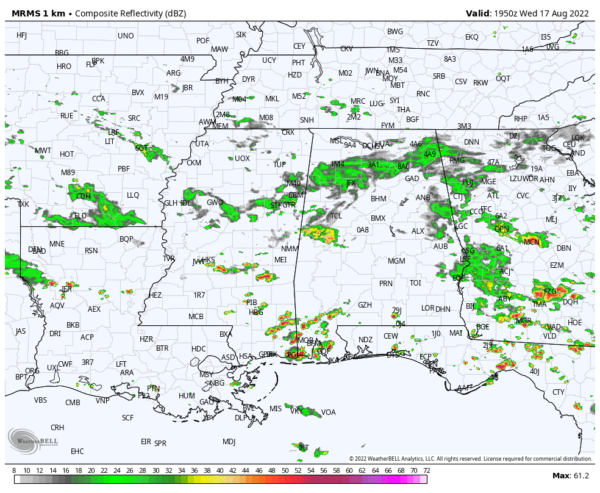
RADAR CHECK: Patches of mostly light rain linger over North Alabama this afternoon, while heavier thunderstorms are forming over the southwest part of the state, where the air is hot and unstable. Sunshine is fairly limited, and temperatures are only in the 70s over the northern counties thanks to clouds and showers. The heavier storms over Southwest Alabama will taper off after sunset; clouds linger much of the night with a few lingering showers around.
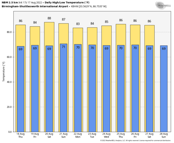
REST OF THE WEEK AND THE WEEKEND: A pool of relatively deep moisture will be in place tomorrow through the weekend, meaning scattered to numerous showers and thunderstorms on daily basis. Understand each day it won’t rain everywhere, and the sun will be out at times. But, the overall pattern looks fairly unsettled with a passing shower or storm occasionally. In this pattern some rain will be possible at just about any hour, but the more active storms will come from noon to midnight. Temperatures will remain below average, with highs in the mid 80s on most days.
NEXT WEEK: The overall pattern won’t change. The sky will be occasionally cloudy through the week with scattered to numerous showers and storms around…. and temperatures will remain below average with highs in the 80s. Most global models suggest temperatures will remain below 90 degrees through the rest of August, which is very unusual for summer in Alabama, needless to say. See the daily Weather Briefing video for maps, graphics, and more details.
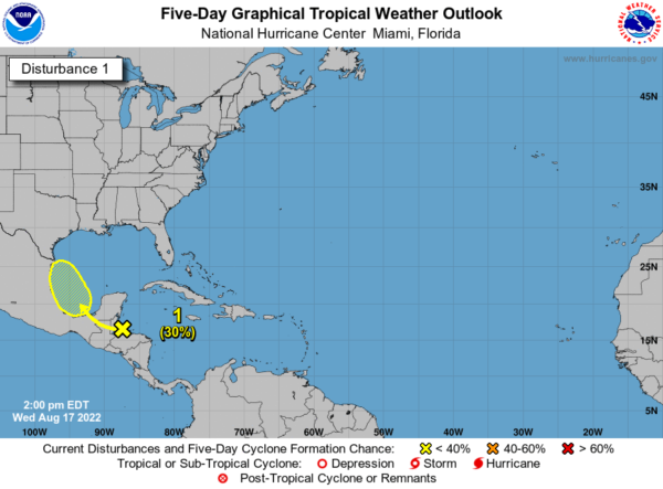
TROPICS: A tropical wave over the northwestern Caribbean Sea is forecast to move across Central America during the next couple of days and emerge over the Bay of Campeche, where an area of low pressure could form on Friday. Some gradual development of this system is possible while it moves northwestward over the southwestern Gulf of Mexico through the weekend. NHC gives the system a 30 percent chance of development over the next five days… the rest of the Atlantic basin remains very quiet.
FOOTBALL WEATHER: For the first week of high school football Friday night, a few showers and storms will be around at kickoff time. The rain will be scattered, and it certainly won’t rain at all stadiums. But, just be aware that a lightning delay can’t be ruled out in a few places. Temperatures will fall from the low 80s at kickoff into the 70s by the second half.
ON THIS DATE IN 1946: An estimated F-4 tornado killed 11 people and injured 100 others in the Mankato, Minnesota area around 6:52 PM. The deaths and most of the injuries occurred in the complete destruction of the 26 cabins at the Green Gables tourist camp, 3 miles southwest of Mankato. A 27-ton road grader was reportedly hurled about 100 feet. Another tornado an hour later destroys downtown Wells, Minnesota.
ON THIS DATE IN 1969: Hurricane Camille slammed into the Mississippi Gulf Coast. It is the second most intense tropical cyclone on record to strike the United States, behind the 1935 Labor Day hurricane, and one of only four hurricanes to be at category five strength at the time of U.S. landfall (the others were Hurricane Andrew in 1992, and Hurricane Michael in 2018). Camille caused tremendous damage in its wake, and produced a peak official storm surge of 24 feet. The hurricane flattened nearly everything along the Mississippi coast, and caused additional flooding and deaths inland while crossing the Appalachian Mountains of Virginia. In the U.S., Camille killed more than 259 people.
BEACH FORECAST: Click here to see the AlabamaWx Beach Forecast Center page.
Look for the next Weather Xtreme video here by 6:00 a.m. tomorrow…
Category: Alabama's Weather, ALL POSTS, Weather Xtreme Videos


